Many have written about, and expounded upon, what the true purpose of a federal government should be—there was a consensus in this regard that was derived in the US some 200 years ago that there are six specific directions that should be addressed: defense, justice, unity, domestic tranquility, citizen betterment and ensuring liberty for all citizens.

SBIRS launch photo: The US Air Force’s 45th Space Wing supported United Launch Alliance’s successful launch of the third Space Based Infrared Systems Geosynchronous Earth Orbit spacecraft aboard an Atlas V rocket from Launch Complex 41 on January 20 at 7:42 p.m. ET.
The primary purpose—no, obligation—of a government is the protection of citizens from foreign and/or internal attack, whether of a physical or economic nature.
Certainly, in the first instance, this is no small task, given today’s global conditions where all are witness to the constant and deadly incursions that intend to destroy and prevent an individual’s right to “life, liberty and the pursuit of happiness.”
Medieval dogmas that are mis-represented by archaic distortions of faiths, misinterpretations of policies and other malconformation of facts, drive unwarranted aggression. Such must be countered via strong intelligence to build appropriately configured defensive and offensive policies and actions.
One such crucial tool to build intelligence and surveillance knowledge to offset hostile intentions are the Space Based Infrared Systems Geosynchronous Earth Orbit (SBIRS GEO) satellites.

The latest and greatest of these spacecraft was launched on January 20 at 7:42 p.m. aboard a United Launch Alliance Atlas V rocket from Cape Canaveral Air Force Station (CCAFS).
Lockheed Martin is the spacecraft’s prime contract and SBIRS was built at the company’s Sunnyvale, California, facility, being flown to Florida aboard a C-5 Galaxy aircraft from nearby Moffet Federal Air Field—and the payload integrator is Northrop Grumman Electronic Systems.
The SBIRS program is the follow-on capability to the highly successful Defense Support Program (DSP). The SBIRS program was designed to provide a seamless operational transition from DSP to SBIRS and meet jointly defined requirements of the defense and intelligence communities in support of the missile early warning, missile defense, battlespace awareness, and technical intelligence mission areas.
The first and second GEO satellites were launched on an ULA Atlas V rocket from Space Launch Complex (SLC) 41 CCAS. Using updates to the Increment 1 ground system, the SBIRS Mission Control Station (MCS) manages the constellation of HEO sensors, GEO satellites as well as the legacy DSP satellites.
Increment 2, the next major SBIRS ground update, was divided into two software releases; Block 10.3 and Block 20. Block 10.3 was transitioned to operations in the fall of 2016 and replaced all of the Increment 1 software, as well as improved event detection.
The SBIRS Survivable/Endurable Evolution (S2E2) program replaced the aging MGS that was initially designed for support of DSP operations in the 1960s and supports SBIRS survivability and endurability requirements.

Artistic rendition of the third SBIRS GEO satellite. Image is courtesy of Lockheed Martin.
The SBIRS sensors are designed to provide greater flexibility and sensitivity than the DSP infrared sensor and detect short-wave and mid-wave infrared signals, allowing SBIRS to perform a broader set of missions.
These enhanced capabilities result in improved prediction accuracy for global strategic and tactical warfighters. The on-going evolution of the ground system uses improved mission processing software, resulting in increased event message accuracy, and reduced manpower for support and operations of the DSP and SBIRS portfolio.
The GEO spacecraft bus consists of a militarized, radiation-hardened version of the Lockheed Martin A2100 spacecraft, providing power, attitude control, command and control, and a communications subsystem with five separate mission data downlinks to meet mission requirements, including system survivability and endurability requirements. The GEO infrared payload consists of two sensors; a scanner and a step-starer.
The scanning sensor continuously scans the Earth to provide 24/7 global strategic missile warning capability. Data from the scanner also contributes to theater and intelligence missions. The step-staring sensor, with a highly-agile and highly-accurate pointing and control system, provides coverage for theater missions and intelligence areas of interest with fast revisit rates and high sensitivity. Similar to the GEO scanning sensor, the HEO sensor is a scanning sensor, with sensor pointing performed by slewing the full telescope on a gimbal.
Both the GEO and HEO infrared sensors gather raw, unprocessed data that are down-linked to the ground, so that the same radiometric scene observed in space will be available on the ground for processing. The GEO sensors also perform on-board signal processing and transmit detected events to the ground, in addition to the unprocessed raw data.
This latest launch was the third SBIRS satellite to gain orbit and was pushed from CCAFS to advance the replacement of the legacy Defense Support Program (DSP) constellation, which has been in operation since 1970.

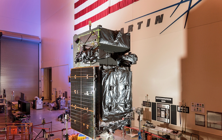
GEO Flight 3 satellite uses infrared surveillance to provide early missile warning for the US military. Artistic rendition is courtesy of Lockheed Martin.
A fourth SBIRS satellite is currently in production, with the propulsion module having been already completed for this spacecraft—before the planned launch in 2017, this flight will move through final assembly, integration and test operations.
Brigadier General Wayne Monteith, the commander of the 45th Space Wing and the mission Launch Decision Authority, heartily congratulated ULA, SMC and the entire integrated team who ensured the success of this, the first of potentially 30-plus launches in 2017. “Once again,’ he added, “the entire team worked hand-in-hand to make this another successful launch for the Air Force and our nation. This launch clearly demonstrates the successful collaboration we have with our mission partners as we continue to shape the future of America’s space operations and showcase why the 45th Space Wing is the ‘World’s Premier Gateway to Space.’”
SBIRS brings the critically-needed capabilities of missile launch warning and defence (identifying significant heat events), battlespace awareness and technical intelligence to the forefront, as the spacecraft brings global and persistent infrared surveillance capabilities to the armed forces.
If an enemy ICBM launch is detected, SBIRS detects that missile’s thermal signature to relay that data to the missile defense forces to negate that incoming threat. Also detectable will be indications of human activity, from military actions to forest fires, small explosions to land clearing and so on.
There are two main sensors, with one undertaking large geographic area scans and the other perpetual, small area surveillance. A combination of these two sensors will afford a more timely alert should missiles be launched anywhere across the globe.

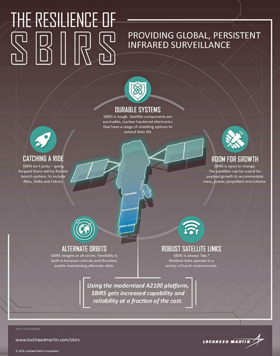
SBIRS infographic courtesy of Lockheed Martin.
When a launch is detected, data is transmitted from SBIRS to the data processing center that plots the exact position of the missile launch, the threat presented and the trajectory of the missile, which in turn leads to a final assessment as to the action required to counter the potential menace to the nation.
Global, Persistent, Infrared Surveillance
SBIRS is an orbiting network of satellites with flexible ground processing and control systems to provide a continuous view of the Earth’s surface. SBIRS collects and transmits infrared (IR) data that is vital for early missile warning and defense.
GROUND SYSTEM
HEO PAYLOAD
• Ground assets manage data from satellites, payloads and the legacy Defense Support
• Program using a distributed, high-availability server architecture
Key Functions:
• Mission planning/payload tasking
• Constellation management/telemetry tracking and commanding
• Mission processing, event reporting and data distribution
The prime contractor for SBIRS is Lockheed Martin. Northrop Grumman is the payload contractor. Photo: Lockheed Martin.
Ground Control:
• Operating modes include normal, survivable and endurable
• Worldwide primary and backup mission control stations, relay ground stations
The newest missile warning satellites are based on the modernized A2100 spacecraft—a no-cost update that reduces costs and cycle times while increasing the potential to incorporate future, modernized sensor suites.
Beyond Missile Warning
A powerful asset for situational awareness, data from SBIRS is being applied across areas such as battlespace awareness, intelligence and 24/7 tactical alerts. Additionally, the Air Force’s Data Utilization Lab is bringing together government, industry and academia to better understand how SBIRS data can be applied for both civil and military applications.
Once SBIRS was on orbit, the airmen from the 460th Operations Group made history by successfully completing the first series of satellite and antenna communications from the satellite from January 28-30 from Block 10, which is the new operations floor at Buckley Air Force Base, Colorado.
This was the first step in transforming Block 10 into the new, consolidated operations floor for Defense Support Program, Highly Elliptical Orbit (HEO) and Geostationary satellites. Currently, each type of satellite communication platform is in a separate location across Colorado, making efficient communication difficult.
By bringing the three units together, the SBIRS constellation is now consolidated under a single roof. Wing and operations group leadership were at Block 10 on January 28, waiting to see history made—a celebration broke out when the commands to SBIRS were successfully returned.
“The intent of Block 10 is to bring all three platforms here in one place to the Mission Control Station,” said Captain Natasha Rosario, the 2nd Space Warning Squadron SBIRS satellite engineering chief. “It was kind of fun. They sent the very first one, which was on DSP, and everyone clapped after the first command went out. They were like, ‘yes it worked!’”

A full year-and-a-half could be required until all three platforms are working on the Block 10 floor. When that does occur, Block 10 will then be known as Mission Control Station 2, Rosario said. There will be a period of checking out the Block 10 system and software, assuring the ground software delivery can be executed flawlessly.
“We’ve put testing and rehearsals and practices in place to make sure that we not only check out the system, but that the people are also ready and bringing those two things together as well,” Rosario said.
Starting with live, single communication, which is what they have already initiated, the 460th OG will continue testing their communication with only one satellite or antenna at a time.
The second stage, which will be communicating with two satellites or antennas simultaneously, will then start in the next month or two—for example, communicating with GEO and HEO simultaneously. An estimated year from this writing, the 460th OG will have full, simultaneous communication with the entire SBIRS constellation.
This advancement means a great deal for the 460th OG and Team Buckley. The squadron will almost double in size and many OG Airmen will have to undertake additional hours of training to keep up with the transition to Block 10.
Airmen from the other Colorado SBIRS locations are scheduled to move to Buckley to finish the transition and unify the SBIRS constellation.
“This is a major milestone for a multi-billion dollar system toward a critical national mission in which we have been diligently working for a very long time,” said Colonel Michael Jackson, the 460th OG commander.
Additionally, for the first time, infrared data from the Lockheed Martin-built SBIRS will be available for new military and civilian uses at the Air Force’s recently opened data utilization lab in Boulder, Colorado.

The radomes, lightly referred to as “golf balls,” on Buckley Air Force Base, Colorado, house and protect satellite dishes and other crucial space operations equipment. The purpose of the giant spheres is to protect the equipment from the weather. Photo is courtesy of US Air Force / Airman 1st Class Emily E. Amyotte.
While SBIRS’ primary mission is strategic missile warning, the system can support a wide range of research and development projects across the field of remote sensing, which is the monitoring, observing and gathering of information on the Earth and atmosphere from space.
“SBIRS uses powerful overhead sensors that collect and transmit significant amounts of infrared data,” said David Sheridan, vice president of Lockheed Martin’s Overhead Persistent Infrared (OPIR) systems mission area. “By giving researchers access to this data, our objective is for them to find new, innovative uses for improving situational awareness—whether it is for tactical military missions, natural disasters or even firefighting.”
In the past year, the Air Force has seen a growing demand from the military, intelligence and civil communities, as well as academia, for remote sensing capabilities.
For areas such as battlespace awareness, intelligence and 24/7 tactical alerts, promising solutions developed in the lab will be considered for operational applications at the SBIRS Mission Control Station, OPIR Battlespace Awareness Center at Buckley Air Force Base, Colorado.
“In an effort to develop, test and transition new or enhanced capabilities, the data utilization lab will provide an opportunity for users, data consumers and third-party developers to access these sensor feeds—providing an open framework architecture to host new tools, algorithms and processing solutions,” said Lt. Colonel Ross Johnston of the Air Force Space and Missile Systems Center.
Along with government and industry teams, academic organizations, like the University of Colorado, will use the data provided by the lab to facilitate collaboration and support research in areas that include monitoring the Earth’s surface to determine the potential for forest fires or informing critical decisions during active fires.
“The benefit of having public-private partnerships is that we can bring together different stakeholders, in addition to doing research, and understand how we can use data from space assets to solve societal issues,” said Scott Palo, associate dean for research at the University of Colorado’s College of Engineering and Applied Science. “We can also provide opportunities for students, as well as small and medium-sized businesses, to connect with industry and government and develop a broader vision that we can all build upon.”
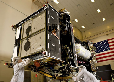
The SBIRS satellite upon build completion. Photo is courtesy of Lockheed Martin.
Word was received from Lockheed Martin that SBIRS GEO Flight 3 is responding fully to commands, as planned, and that event occurred approximately 37 minutes after lift-off.
“After a successful ULA launch, signal acquisition is the first critical event in SBIRS’ mission to support the Air Force with early missile warning and defense,” said David Sheridan, vice president of Lockheed Martin’s Overhead Persistent Infrared (OPIR) systems mission area. “With communications now established, our job begins to deliver SBIRS to its final orbit so we can complete deployments and operational testing in anticipation of the satellite’s formal acceptance by the Air Force.”
“Adding this third geostationary satellite to the SBIRS constellation continues our proud legacy of providing best-of-class OPIR solutions that provide real-time, 24/7 data to our military and allies,” said Robert Mehltretter, vice president, Northrop Grumman Military and Civil Space. “We are looking forward to seeing our sensors capture the first light of real-time world events shortly, and seeing this data delivered to the warfighter will make us proud.”
The satellite will now begin the transition to the final location in geosynchronous orbit, approximately 22,000 miles above the Earth. There, the satellite’s solar arrays, light shade and antennas will be deployed to initiate early, on orbit testing.
SBIRS GEO-1 and GEO-2, which were launched in 2011 and 2013 respectively, continue to meet or exceed performance expectations. The satellites’ sensor pointing accuracy and sensitivity for detection of targets significantly exceed specifications.
While SBIRS’ primary mission is strategic missile warning, infrared data will also be made available for new qualified military and civilian applications at the Air Force’s recently opened Tools, Applications and Processing Lab in Boulder, Colorado.
The next satellite, GEO Flight 4, will undergo final assembly, integration and test prior to its planned 2017 launch. SBIRS GEO-5 and GEO-6, which are currently in production, incorporate a new common spacecraft bus, the modernized A2100, to dramatically reduce costs and cycle times while increasing the potential to incorporate future, modernized sensor suites.
A sure indicator of the effectiveness of satellite surveillance for intelligence purposes is the drive by China in the development of their anti-satellite (ASAT) weaponry.
One example of the Chinese intent to enhance these capabilities was their launch of their SC-19 missile a few years ago that used kinetic energy versus an obsolete orbiting satellite. The resultant "warning light" strobed across the globe and the Pentagon realized efforts had to be expended to counter such spatial threats—without the intelligence provided by the superior technologies of the satellite, accessing the tools and information available to defend a nation become severely crippled or, heaven-forbid, totally non-existent.

Photo of the ULA Atlas V rocket carrying SBIRS GEO Flight 3 satellite from Space Launch Complex-41 at 7:42 p.m. ET. Photo is courtesy of ULA.
And therein rests one of the more important reasons for the commitment by the USAF of more than $5 billion over the next five years in development of technologies to counter such adversarial threats to spacecraft. One such effort is the “hardening” of satellites in order for them to become immune to electronic warfare attacks.
Another undertaking was by the Defense Advanced Research Projects Agency, known as DARPA, whose wide-angle space view can detect launch concerns as well as asteroids that threaten the planet.
There are also efforts underway to develop GPS-denied environments for satellites that would allow positioning navigation as well as timing mechanics to function without that technology.
For United Launch Alliance (ULA), this was the first of 11 planned launches for this year and the 116th successful launch since the company's formation in December of 2006.
The 401 configuration of the Atlas V Evolved Expendable Launch Vehicle (EELV) included a 4 meter in diameter large payload fairing (LPF). Propulsion was provided by the RD AMROSS RD-180 engine, with the Centaur upper stage powered by the Aerojet Rocketdyne RL10C engine.
Laura Maginnis, the Vice President at ULA for Government Satellite Launches, indicated that the 401 configuration has become the workhorse of the Atlas V fleet and has delivered half of all of the Atlas V missions to date. She added, "I can’t think of a better way to kick off the new year.”Supporting this crucial launch was Aerojet Rocketdyne, Inc., whose propulsion systems on the Atlas V included the RL10C-1 upper-stage engine, six helium pressurization tanks, and 12 Centaur upper-stage Reaction Control System thrusters (RCS). Additionally, Aerojet Rocketdyne provided 18 monopropellant hydrazine thrusters on the GEO Flight 3 satellite.

Aerojet Rocketdyne's RL10 upper stage engine. Photo courtesy of Aerojet Rocketdyne.
Aerojet Rocketdyne's RL10C-1 upper-stage engine ignited after separation of the first stage to place the payload into orbit, helped by the Centaur RCS thrusters and pressurization tanks. The RL10C-1 delivers 22,890 pounds of thrust to power the Atlas V upper stage, using cryogenic liquid hydrogen and liquid oxygen propellants. The RL10C-1 was developed from the RL10 family of upper-stage engines, which have accumulated one of the most impressive track records of accomplishments in the history of space propulsion.
More than 475 RL10 engines have supported launches over the last 50 years, playing a vital role in placing military, government and commercial satellites into orbit, and powering scientific space-probes on every interplanetary mission in our solar system. Aerojet Rocketdyne provided 12 MR-106 monopropellant hydrazine thrusters in four modules on the Atlas V Centaur upper-stage, which provided roll, pitch and yaw control, as well as settling burns. The GEO Flight 3 satellite has 18 monopropellant hydrazine thrusters onboard: 12 MR-103G 0.2-lbf thrusters and six MR-106L 5-lbf thrusters.
Once separated from the launch vehicle, the 18 thrusters on the GEO Flight 3 satellite provided stationkeeping, three-axis control and de-spinning of the reaction wheels throughout the mission. They also provide attitude control during orbit-raising, as well as the impulse needed for final decommissioning of the satellite.
ARDÉ, a subsidiary of Aerojet Rocketdyne based in New Jersey, provided the pressure vessels on the first and second stages of the launch vehicle.
“It’s an honor to know our propulsion systems helped place another critical satellite into orbit in support of our nation’s defense—one that will provide key capabilities in the areas of missile warning, missile defense, technical intelligence and battlespace awareness,” said Aerojet Rocketdyne CEO and President Eileen Drake.
Article includes an editorial contribution by:
Airman 1st Class Emily E. Amyotte, 460th Space Wing Public Affairs, USAF
lockheedmartin.com
losangeles.af.mil
ulalaunch.com
rocket.com