For more than a decade now, the demands of two wars, regional unrest and natural disasters around the world have driven the Intelligence Community (IC) to develop better information pieces to apply to the intelligence puzzle: More useful signals information, satellite imagery, Unmanned Aerial Systems, aerial and satellite full-motion video, multi-camera generation, three-dimensional images, human intelligence and on it goes.
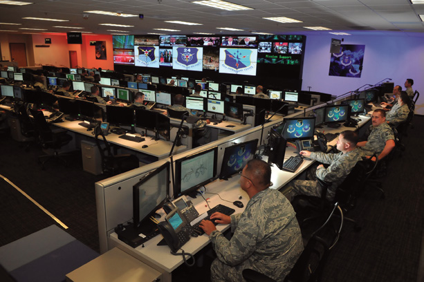
The modern command operations center.
Analysts at fusion desks in Distributed Common Ground Stations assemble these pieces, often in time-consuming processes, to create a Geospatial Intelligence picture. However, Big Data threatens to swamp the process and its practitioners, generating a need for dynamic tools that automate and enhance data preparation, allowing the specialists to apply more of their time to analysis.
The Activity-Based Intelligence (ABI) paradigm has emerged to solve this problem. Built on the geospatial intelligence foundation, ABI can take today’s picture of the enemy over the hill or around the urban corner and combine it with yesterday’s picture and another from last week. It adds other puzzle pieces to better predict if the hostiles will be there tomorrow, and what the enemy is capable of doing in that location, as well as what any associates are doing 10 miles away.
An exciting advancement, ABI exploits improvements in sensor development, information management, analysis, sharing, and enhancing intelligence activities. Rather than focusing collection and analysis efforts on a single target, the approach assesses a wider variety of data – both conventional and unconventional—over a period of time and, in doing so, provides better insight into patterns of behavior and future activities.
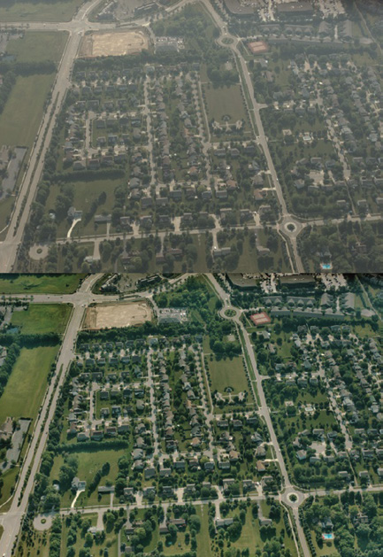
A comparison of two images shows how automatic dehazing improves the quality and usability of imagery, allowing the analyst to make better decisions
The technology’s grounding in multi-intelligence fusion makes ABI even more exciting and demanding, as it involves uniting data from disparate geospatial sources with unstructured and seemingly mundane information—such as documents, business system data and business intelligence, along with archives—into an integrated analytical environment for detecting trends that offer context: The what, when and where, and even the how and why, elements of a comprehensive geospatial story that can drive smarter decision-making.
Modeling input can clarify that decision, and the fused elements can be subsequently recombined by others for their own uses. Those supporting the decision makers have to work with data across time, and to do so they must connect through an Enterprise Information Management foundation, one that also integrates with capture platforms and sensors to automate and speed the processing of their inputs.
To accomplish these tasks, ABI solutions establish real-time connections to as many raw intelligence collections as possible. The ability to bring imagery intelligence (IMINT), signals intelligence (SIGINT), human intelligence (HUMINT), Measures and Signatures (MASINT), and other sources into an integrated analytical environment provides a powerful setting to assist analysts in detecting trends they might not otherwise see.
Feeds from one source of intelligence can also provide cues to specific segments of data from other sources, leading to a more meaningful analysis. One segment also can help to validate or discount another.
The mission requires doing all of this quickly, extracting from stovepipes a meaningful array of information. With the Middle East wars winding down, there is also a demand for increased flexibility in intelligence gathering and exploitation to meet needs as varied as those of U.S. Special Operations, which is present in as many as 100 countries at any one time; of disaster relief agencies working in places such as Southeast Asia in the aftermath of Typhoon Haiyan; and with military and civilian agencies monitoring ongoing tensions in Syria and elsewhere among Arab Spring nations.
To meet this goal, intelligence, defense, national security and disaster assistance agencies require a portfolio that provides best-in-class data capture, GIS, remote sensing and photogrammetry capabilities, as well as the synthesis of these technologies in server-based products specializing in data management, spatial data infrastructure, workflow optimization, web editing and web mapping.
As exciting as ABI has become, its development and improvement has to be accomplished in the constraining environment of fiscal austerity in which it competes with other defense, security and disaster relief elements for funding. Fortunately, it is now possible to tie all of these components together cost effectively to achieve a complete end-to-end capability that advances security efforts on a global scale.
For example, tying together sensor-based data capture of geo-referenced position and terrain information with data processing, including orientation and triangulation, creates a cross portfolio capability that benefits border security, police forces, defence and intelligence and more. This also includes 3D feature collection and editing, as well as digital terrain model collection, editing and enhanced visualization.
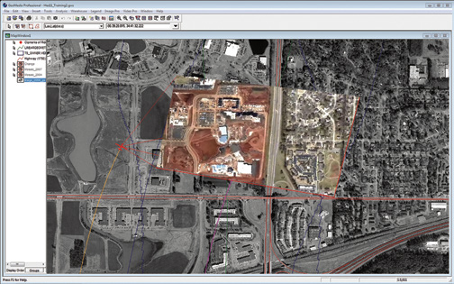
Displaying real-time UAV video feeds and other geospatial data over a satellite image provides improved context an understanding of unfolding activities in the area of interest.
In terms of sensor integration, this could also include Radar Operational Surveillance Systems in which technology integrates satellite-based AIS data from exactEarth and other satellite-based radar systems.
New industry solutions also play a key role in helping large systems integrators meet their government customers’ challenges. Aligning with customer requirements, a fully customizable geospatial SDK can help these organizations seamlessly embrace the solutions’ capabilities.
These tools meet the needs of a dynamic geospatial approach to intelligence gathering and exploitation, as does the implementation of the open Web Processing Service (WPS) standard, which greatly extends the reach and value of the models analysts develop. By using a simple, standards-based web interface, non-domain experts can apply powerful modeling, analysis and data manipulation without the need of extensive training or specialist hardware.
With more capability, and more users for that capability, the IC can call on an ever-developing array of tools to exploit more and different intelligence pieces to generate a clearer picture that is the product of decades of evolution in the field. And those pictures can be used in ways that are more numerous, diverse and powerful than ever.

About the author
Sven Bues is the Vice President, EMEA Defense & Intelligence Sales, at Intergraph. Sven served in the German Armed Forces until 1996 and studied mechanical engineering during his military service. In the last position of his military career, he served as an army officer for the drone reconnaissance system CL-289.
* * * * * * * * *
For 40 years, Intergraph has been a trusted partner of defense and intelligence agencies. Drawing from the firm’s solid engineering heritage and open standards architecture, brought together are people, data, and systems for faster, more accurate decision making. Their geospatially powered solutions transform vast amounts of complex data into actionable intelligence, protecting U.S. and global interests and supporting the warfighter. The company’s solutions and IT services help clients build and manage geospatial databases, produce operational maps, manage critical enterprise content, analyze and fuse geospatial intelligence, manage weapon support systems, and ensure the security of military bases and installations worldwide. GeoMedia 3D is the latest addition to the Intergraph GeoMedia product suite, a set of well-integrated applications that offer a wide range of geospatial processing capabilities. GeoMedia 3D is a GeoMedia add-on product that extends the functionality of Intergraph’s geospatial solutions through an integrated 3D visualization and analysis environment.