
The Dean of the Mitchell Institute, retired General David Deptula, opened the forum with the following comments before turning the microphone over to General Shelton for his speech.
Mr. David Deptula
First and foremost, I am very pleased that you [the forum guests] were all able to make it here to our inaugural Friday Space Group breakfast. Over the next few months, we’ll look forward to hosting an array of leading figures to discuss key topics that relate to our ability to secure desired effects in, through and from the space domain.
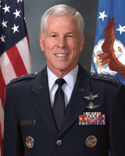
General William Shelton, Commander, Air Force Space Command
These issues are especially important to the Mitchell Institute and fall directly in line with our mission statement. Pardon me for making a little bit of an advertisement for the Mitchell Institute, but we have three principal objectives. Our mission is to, one, educate about aerospace power’s contribution to America’s global interests; two, to inform the policy and budget deliberations that go on just across the street over here; and three, to cultivate the next generation of policy leaders to exploit the advantages of operating in air, space and cyberspace. I think everybody here would agree with those and I look forward to your participation and helping it come to fruition.
I’m really pleased and honored to have the opportunity this morning to introduce my good friend General Willie Shelton, who is the Commander of Air Force Space Command. He’s responsible for organizing, training and equipping mission ready space and cyber space forces for North American Aerospace Defense Command, U.S. Strategic Command, and all the other combatant commands around the world. General Shelton oversees Air Force network operations, manages the global network of space command and control, communications, missile warning and space launch facilities, and he’s responsible for space system development and acquisition as well. He leads more than 42,000 professionals assigned to 134 locations worldwide.
Before I hand over the mic to General Shelton, I would like to thank the Air Force Space Command team for turning the concept of this program into reality. I’m sure we’ll have very many good sessions ahead. We couldn’t have done it without their hard work.
I’d also like to recognize General Craig McKinley, President of the Air Force Association, and also a good friend. It’s due to his leadership that a re-invigorated Mitchell Institute is alive and well today. Without further ado, General Shelton, the podium is yours.
General Shelton
Well it’s good to be here this morning. I want to spend a few minutes on some broad aspects of what we’re doing in space these days, what we’re thinking about for the future, but I want to allow plenty of time for Q&A at the end so I’ll try to keep this brief.
First, let me lay down what I think are some first principles, things to think about as we talk about what we’re doing in space now and looking toward the future. I hope everybody here will just stipulate that there’s a big dependence on space in the United States military today.

I don’t think we need to debate that. I don’t think I need to belabor it. I think everybody just kind of understands that every service is absolutely a big player in space—every service. Every operation we conduct in the United States military today touches space somehow, and I mean everything from humanitarian relief operations all the way to major combat operations. Space is imminently involved.
Second principle, there are big changes that have occurred in the space domain over the past several years. First, the number of players in space. It wasn’t all that long ago, and maybe it’s because I’m an old guy now, but I can remember not that long ago where it was pretty much just us and the Soviet Union in space. There are many countries now that have either their own satellite in space or they have, through some consortium, a financial interest in a satellite in space—almost every country on the planet.
There are 11 countries now with indigenous launch capability—that tells you something about the growth in space traffic. And that has caused space debris. That is a tremendous problem for us.
Right now, we track roughly 23,000 objects in space on a daily basis. We know from our modeling, we project from our modeling, that there are some 500,000 pieces larger than one centimeter that we can’t track. So think about that. If maybe a two to three centimeter sized object can be lethal to fragile satellites, we’ve got a lot of traffic in space that we need to be worried about and we just can’t track it right now.
Not to mention the threats that are in space, the growing threats in space, anything from jamming, which is very easy to do, all the way up through laser activity, to kinetic ASAT activity. All of this has caused us to rethink how we’re doing space. I’ll talk more about that later.
Third, I don’t know of any near- or mid-term alternatives to space. So if you’re thinking about well, okay, if this is a real problem for us, all these threats, all the debris, maybe we need to decrease our reliance on space, I don’t know how you do that.
I know of nothing out there that will give us the global capacity, the global access that we need in space. If we’re going to be a global power, we have to have global access to these capabilities at times and places of our choosing. So, no mid-term, no near-term alternatives to the capabilities we’ve got today.

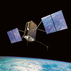
Space-Based Surveillance System satellite. Image is courtesy of Boeing.
The fourth major principle—blinding flash of the obvious to this crowd—declining budgets. So just at a time when we need to get better at what we’re doing here, we’re having to face declining budgets. So how do we get better in space? How do we get better across the Department of Defense, really, in an era of declining budgets?
Fifth, and the last one, I just don’t see the status quo is going to work for us. Given those four things I just listed, the status quo is certainly an option, but I just don’t think it’s a viable option for us.
What are we doing to address these five principles I just laid out? First, let me talk about Space Situational Awareness (SSA). I think that’s job one for us. All space ops, from launch all the way through disposal of satellites, is dependent on our ability to do a good job at SSA.
Debris Difficulties + SSA
In Low-Earth-Orbit (LEO), we’re certainly concerned about the debris problem. We’re concerned about the threats that are largely focused on LEO. They’re expanding into higher orbits as well, but for right now those threats are largely concentrated in LEO.
We know that we’ve got to get better at SSA because of the debris problem, because of the threat problem, so we’re in the acquisition process right now to build a Space Fence out on Kwajalein that will give us the ability to track much smaller objects, a greater volume of traffic as well. It will be located at Kwajalein, close to the equator, so we’re covering almost the full scope of orbits, darn near zero degrees. Nobody flies at zero degrees right now, but if anybody did we would come pretty close to having that covered as well. Depending on the design that comes in on Space Fence, we might be able to get all the way to zero.
We’re also moving a C-band radar off the island of Antigua, one that was used for space launch operations, to do space tracking from Australia. A great partnership with our Australian partners, and I’ll have another example of that in just a second.
Go up to GEO. Some of our most precious assets fly at 22,000 miles up in space. Talk about missile warning, talk about protected communications, talk about just Wide-band Communications, the geosynchronous orbit is very valuable to us.
Right now we don’t have really great coverage of geosynchronous orbit. If you think about a radar going that far up into space, it’s a pencil beam. It doesn’t do a good job of synoptic coverage and warning. It’s literally a pencil beam that goes up.
We know where the object is. We can go up and find it. But from a search point of view, it just doesn’t do that job.
This means we have to do it with optical devices. Most of our optical devices are on the ground, or on the planet, but those are subject to being weathered out and they’re also only good during night-time viewing. We’ve got one dedicated satellite up right now. It’s called the Space-Based Surveillance System. We stayed up all night thinking of that name.
The Space-Based Surveillance System does a great job—every 100 minutes it comes around and just kind of vacuums up what’s going on in geosynchronous orbit. You can imagine how valuable that is. We’ve got to sustain that capability.
We think this satellite will likely hit end of life sometime around 2017. The great news is our industry produces satellites that last longer than we think they will. We’re hopeful that this one does because the follow-on is in question right now. But we have got to sustain this capability.
We’re also moving a telescope. DARPA actually built a telescope down in New Mexico. We’re going to pick that telescope up and move it down to Australia, pretty close to where the C-band radar is going to be located. And that is a wonderful telescope that has great synoptic coverage. It moves and settles very rapidly, just a great piece of engineering, and it’ll do a good job of giving us some Southern Hemisphere coverage down in Australia.

The big move, though, is pulling all the data together. You know, we’re really not data poor in this business. We’re actually pretty data rich.
But we don’t have a way to fuse all this data. We’re operating right now on a kind of 1994 software package and a 1980s computer package at the Joint Space Operations Center out at Vandenberg—SPADOC, Space Defense Operations Center, the old SPADOC. We picked it up out of Cheyenne Mountain and moved it out to Vandenberg. A lot of people said you wouldn’t be able to do that. It would break. We wouldn’t be able to operate it. Well, we did it. We moved it out to Vandenberg Air Force Base.
But it’s old technology. So, the Joint Space Operations System Center, Mission System, JMS, is our answer to the problem we’ve got right now with computing capability. We will establish a high performance computing environment. We’ll be able to bring in data from disparate sensors, such as missile defense radars, if we can move towards that.
You know, God forbid we really need to use missile defense radars for what they’re designed for. The rest of the time, why not use them for space surveillance? We’re working that as well.
But being able to ingest that data, being able to process all that data, being able to process all the data that’s going to come off the Space Fence, we’re going to need this high performance computing environment to get this done. We’re working very hard to get to a much better posture in what we can do with all this data that’s available to us, and do a much better job of Space Situational Awareness.
We’re also working very hard on survivability and resilience of our constellations. I think it’s kind of silly to just sit back and realize that you’ve got all these threats developing, that you’ve got this debris problem, that you’ve got the chances of premature failure of satellites.
Now we’ve built a lot of redundancy into our satellites, but there were still cases in the past, in the not too distant past, where we’ve had literally heart-breaking failures after maybe only a year on orbit. When you have those kinds of failures, and we’re building satellites just enough, just in time, because of how expensive they are, you potentially open up a big hole in our constellations. And some of them, as I said before, are just so precious to how we do business in the United States that we can’t afford to have those holes.
Constellations
Let me talk about two satellite constellations, in particular, that we’re working very hard on to examine survivability and resilience.
First, our Advanced Extremely High Frequency Satellite, AEHF. That’s the satellite that provides communications capability for the president to deployed forces, to his continuity of government forces, all those kinds of things in kind of dire crises for the United States. We’re building a constellation of four of those satellites, and those satellites are very expensive. If an adversary wanted to go after one of our satellites, that might be the one you’d choose. If that happened, and one of the four gets knocked out, we’re left with a big geographic hole in our ability to transmit data around the world and the president to give the direction that he needs to give.
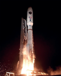
The 45th Space Wing successfully launched a United Launch Alliance Atlas V rocket carrying the third Advanced Extremely High Frequency (AEHF-3) satellite from Space Launch Complex-41 at Cape Canaveral Air Force Station on September 18, 2013. Photo by Pat Corkery, United Launch Alliance.
Same thing with our Space-based Infrared System, our missile warning satellites. We’re building a constellation of four of those. If we get a big hole in that constellation, a big geographic hole in that constellation, you don’t sense the missile launches that are coming off the planet.
Now the great thing about our IR satellites in orbit, we can tell you any time something launches on the planet. We can tell you what the launch point is. We can tell you where it’s going.
We can tell you the type of missile it is. We can tell you what the impact point is going to be within a pretty decent ellipse. You can imagine the value of that and the value of that to the president as he considers his options for response if the United States is under attack.
We’ve got to work pretty hard to look at the resilience and the survivability of those two constellations in particular. The solutions that we’ve postulated include things such as disaggregation. You’ve probably all read about disaggregation and probably everybody has their own ideas on what that really means. Well let me tell you what we think it means.
We think it means lowering the overall complexity of a given satellite. Advanced EHF, for example, has tactical and strategic protected communications onboard. What if you separated those from one another?
What if you went to a satellite that had protected—you went to another satellite or satellites, or a hosted payload that provided the tactical capability? That would certainly address, at least in some regard, your survivability. There is a little bit of help in numbers alone. That’s not the full answer, but at least that’s a possibility.
We could also drive to smaller satellites, we think, with this kind of thought process. We think that would also help us drive to smaller launch vehicles, which then lowers our launch costs. We think we could also start to think about less redundancy being required. So not only less complexity from having so much smashed onto one satellite, but also lower the complexity overall because you can lower the overall costs, and that starts to open up some design trades for you.
I mentioned hosted payloads. We also think about international augmentation for how we’re doing business. I don’t think we should ever get to the place where the United States doesn’t have the capability to go it alone if we had to. But, there is certainly room for international augmentation to our constellations here, and so we’re looking at that as a design trade as well, or a strategic trade as well.
As we’re looking at all these options, we have really had to make our own money to do the studies. And the way we’ve done that is through what we call efficient space procurement, which is a way of acquiring satellites. You know, because of the way we were required to do appropriations we had to buy satellites one at a time. Well you can imagine how expensive that is, to buy a satellite one at a time and also to provide the full procurement dollars in a given year. There’s these big spikes in the budget that just happen episodically when you have to buy a satellite.

Artistic rendition of the Space-based, Infrared System (SBIRS). Image courtesy of Lockheed Martin.
Permission has been received from the Congress, and we’re very grateful to them for this, for incremental funding and block buys of satellites. Advanced EHF, SBIRS, both of those we’re buying two at a time. Incremental funding is much easier from a programmatic point of view and much cheaper. We’ve taken the savings out of that and put it into what we call Space Modernization Initiative funding, and that money is funding all these studies to look at what our future architectures ought to be.
We are looking hard at the best approaches. We’re also looking to mature certain technologies, such as SBIRS: New sensors, new wide field of view IR sensors to fly that might replace scanning sensors. It would be a wide field of view staring sensor, and that would be a much better thing for us in terms of framework rates on that sensor, and be able to see the activity on the ground.
However, the bottom line here, I believe, if you can kind of imagine a Venn diagram in your mind, there’s an oval that talks about required capability. There’s another oval that talks about affordability. There’s another oval that talks about resilience. So you put these three together and the overlapped space in the center there—there’s a nexus of required capability, of resilience, of affordability. That’s what we’re driving to and that’s what we need to find as we think about resilience and the survivability of our assets.
Unfortunately, because of the long timeline for space acquisition, our die is pretty much cast through about 2025. We’ve already got plans for SBIRS 5 and 6, AEHF 5 and 6, that will take us out through the mid-2020s. We’re having to do the work now to decide what the architecture is going to be beyond the mid-2020s. The threats that are in place now, we’ll be facing those threats with current capability through that timeframe.
Wideband Communications
Let’s talk about wide-band comms. Our Wide-band Global Satellite is the dedicated military system that just pumps the wide-band data around the planet. Six of the ten satellites that we are going to procure under this program are on-orbit now doing very well. International participation with Australia, Canada, Denmark, Netherlands, New Zealand and Luxembourg, so great partnerships there. And, as a matter of fact, Australia bought the sixth WGS satellite so that they could participate in the program, so great capability.
But as we think about wide-band communincations for the future, 80 percent of our comm coming back from Afghanistan today is carried over commercial platforms. We’ve already proven that we can do this over commercial capability. What if we shifted all of the wide-band capability to commercial providers, either through lease arrangements, we buy constellations, whatever? Comm is a service, if you want to think about it that way. That’s one of the options we’re considering. But beyond WGS 10, what’s the right way for this nation to have wide-band comm?
GPS—I’m going to guess that everybody in this room, whether you knew it or not, touched GPS this morning—not this week, this morning—either through your smart phone or your nav system in your car that got you here or a transaction you did at an ATM—you touched GPS. Needless to say, that’s a capability we’re going to have to sustain. The world just wouldn’t have it any other way.
We’ve got 31 satellites on-orbit right now. Some of them are old enough to vote. They’re all doing great. Like I said, industry has produced some wonderful satellites for us that are doing extremely well. But they’re getting a little fragile. We’re a little bit concerned about the long-term viability of some of the satellites there.

Probably the biggest issue here is whether or not we are too dependent on GPS. You know, I talked about the world, and you all touching it, but the military dependence on GPS, I mean, we’ve got artillery shells now that are guided by GPS, for gosh sakes, artillery shells. We’ve got all kinds of bombs that are guided by GPS. Our platforms are guided by GPS.
The timing of our networks, our high-speed networks, are driven by GPS time. Do we have too much dependence on GPS? That’s the question that we’re starting to ask across the Department of Defense.
The answer is not to get off GPS, however. That will never be the answer, in my view. I’ve heard some people talk about that, and we’ve got some great work going on in DARPA to produce chip-scale inertial measurement units, chip-scale atomic clocks, those kinds of things.
However, those aren’t near-term. Those are probably in the mid- to far-term. For the near-term, we’ve got to think about working through things such s GPS jamming.
Jamming GPS is not all that difficult. But that’s why we’re moving to a unique military code, M-code, on GPS. It’s a little bit more jam resistant, spectrally separated from the rest of the GPS signals, so it’s going to provide a much better capability for us.
I know there have been some stories lately about the late delivery of the navigation payload on GPS III. We’re working through those problems. We don’t believe right now—what we know right now, anyway—we don’t believe that there’s going to be an overall impact to the constellation from that late delivery.
The first available launch is going to slip. However, we’re only at four of 12 of our GPS IIFs that we have purchased, so we think we’re going to be in okay shape here. We’re not happy at all about the nav payload slipping, but we think we’re going to be okay.
Weather satellites—weather satellites provide tremendous capability to us from a forecasting point of view. It also enables some other capabilities because of precise forecasts we can provide from low Earth orbiting weather satellites. You know, it’s not enough to look from geosynchronous orbit down to where the clouds are. For military operations, specific requirements are there to use those LEO satellites for much more precise forecasts. We are also working hard with NOAA on the broader space applications of weather sensors and appending weather sensor gaps really that NOAA has talked about very publicly, and you’ve probably read about that.
Our 19th DMSP, Defense Meteorological Satellite Program, our 19th satellite will be launched in May [Editor’s note: DMSP-19 actually launched on April 3, 2014.] We just had the 50th anniversary of DMSP—unbelievable, the 50th anniversary of launching those things.
Speaking of launches, let me talk about launches for just a second and what we’re doing there. Our EELV program has 67 national security launch successes in a row—67. That is unprecedented in the history of space flight. I don’t care what country. I don’t care what you want to talk about. There is no other success record like that.
Statistically, we’re on borrowed time here. But the way we think about this, and the way we work this, is every launch is the first one in a row. We don’t think about mission success in a casual way. We think about mission success as absolute must do on every launch.
GPS III artistic rendition, courtesy of Lockheed Martin
Our ULA partner, United Launch Alliance partner, is doing fantastic work for us. There is no question about it. And they’re working hard with us to get the costs of launch down.
We just went to a block buy. You’ve seen the press on that, I’m sure. We went to a block buy of 36 cores of capability. Sometimes you put multiple cores together to generate a heavy launch, but 36 of those cores. That leaves us 14—I think the requirement is about 50—so 14 are set aside for potential competition.
That competition will allow new entrants into the business to come in and compete for those 14 launches. And that’s up through 17. Eighteen and beyond, we don’t know yet what that will look like. We’re developing that strategy right now.
As I said, no matter what we do here we won’t compromise on mission assurance. We can’t afford to. Each one of these satellites we put up these days, because it’s just enough and just in time, is a precious asset.
Countering The Threats
The last thing I want to talk about is the Space Security and Defense Program. Most of you probably remember the Space Protection Program. This is the new name for the Space Protection Program. But it really indicates an emphasis on space protection, in light of the threats that are coming at us.
They analyze intelligence on potential adversaries and their space programs, and develop options for us on how we can mitigate some of those threats and how we can address some of the space protection questions that are coming out today. There are huge dividends in awareness because of this new program. It’s chartered under the deputy secretary of Defense and the deputy DNI, so it’s at that level that we have these discussions now.
And there’s also a big payoff already in tangible results. Unfortunately, we can’t talk about the details of all that in this forum. But trust me when I say that the SSDP program is doing great work and they will continue to provide, I think, wonderful analysis as well as solutions to some of our most vexing problems.
There’s a lot of activity going on. I’ve just kind of hit the wave tops here, but there are also a lot of study efforts underway to look at what our future needs to be, particularly with regard to alternative architectures. These study efforts are certainly driven by uncertainty: the uncertainty of declining budgets, uncertainty in the threats that are developing. I’ll tell you the considered wisdom of the intelligence community has produced some really good seminal work on the space threats that are out there. And what we are finding is they were maybe a little too conservative. Things are moving much faster than we certainly would like and certainly they had predicted.
There are people in my command who are working extremely hard to define those proper architectures for the future. And it is, as I said, a vital capability for the joint force and we can’t and we won’t let them down in providing them space capabilities.
Thanks for your attention.
About General Shelton
General William L. Shelton is Commander, Air Force Space Command, Peterson Air Force Base, Colorado. He is responsible for organizing, equipping, training and maintaining mission-ready space and cyberspace forces and capabilities for North American Aerospace Defense Command, U.S. Strategic Command and other combatant commands around the world. General Shelton oversees Air Force network operations; manages a global network of satellite command and control, communications, missile warning and space launch facilities; and is responsible for space system development and acquisition. He leads more than 42,000 professionals assigned to 134 locations worldwide.
General Shelton entered the Air Force in 1976 as a graduate of the U.S. Air Force Academy. He has served in various assignments, including research and development testing, space operations and staff work. The general has commanded at the squadron, group, wing and numbered air force levels, and served on the staffs at major command headquarters, Air Force headquarters and the Office of the Secretary of Defense. Prior to assuming his current position, General Shelton was the Assistant Vice Chief of Staff and Director, Air Staff, U.S. Air Force, the Pentagon, Washington, D.C.
For further details regarding the Mitchell Institute, plesae visit http://www.afa.org/MitchellInstitute1