
The National Geospatial-Intelligence Agency is one of a kind; a community of professionals generating a unique type of intelligence for both the national defense and direct combat support.
Those who navigate American ships and aircraft, make national policy, serve on the front lines, respond to natural disasters, or simply invoke GPS on a handheld device rely profoundly on NGA.
The NGA serves as the world leader for timely, relevant, accurate, and actionable geospatial intelligence, or GEOINT. However, this did not happen overnight. Over the past 20 years, the confluence of tradecraft, skill, and vision made GEOINT critical to American efforts all over the world.
Something Happened In Dayton
On November 1, 1995, President Clinton called on the warring factions in Bosnia to end the conflict that had cost more than 300,000 Serb, Croat, and Muslim lives since 1991. He invited their representatives to come to Wright-Patterson Air Force Base in Dayton, Ohio, to negotiate an end to the ethnic discord.
At Dayton the U. S. delegation relied on a technical team led by the Defense Mapping Agency and the U.S. Army Topographic Engineer Center. These agencies drew together a support team of over 50 individuals who digitally mapped the disputed Balkan areas in near real-time to assist the diplomats in their deliberations. The digital renderings included up-to-date terrain visualization with cultural and economic data relating to potential boundaries.

The power and flexibility of the technology and the technicians gave the political decision makers the confidence needed to reach agreement. Three-dimensional visual imagery of the disputed areas permitted cartographers to walk negotiators through disputed terrain, giving them a vivid and virtual experience of the space. In at least one instance, this three-dimensional experience proved crucial in persuading Yugoslav President Slobodan Milosevic to compromise on a disputed area.
These hard-working cartographers and analysts collectively contributed to the Dayton Peace Accords in 1995, leading to a temporary, but significant, suspension of regional violence. In this case, the professional lesson did not go unlearned.
Combining people and talent from eight agencies and offices into the National Imagery and Mapping Agency (NIMA) in 1996 certainly reflected initiatives underway in the Congress, the Department of Defense, and the Central Intelligence Agency after the first Gulf War in 1991. However, this move also spoke to the wisdom of asking those involved in both defense imagery and mapping to emulate the Dayton success on a more permanent basis.
Of course, the agency’s enabling legislation from Congress simply brought people together and initially could do nothing more. For many months after the creation of NIMA, imagery analysis and geospatial information services within the agency remained in separate and culturally distinct worlds.
Seeing the potential in integration, a number of senior defense and intelligence leaders highly recommended that the agency actively integrate the talents assembled under the NIMA umbrella. Strong cultural identities on all sides at times made the idea of imagery analysts and geospatial specialists regularly emulating the Dayton experience a most difficult and most unlikely prospect.
Recognizing possibilities in the combination, a number of people stepped forward to bridge the gap. In one case, a DMA veteran and senior cartographer felt that she might be able to help.
Having worked for a time in private industry on one of the first automobile navigation system studies, the need to integrate skills and personnel to achieve a goal seemed natural. Working with the NIMA Production Cell at the Washington Navy Yard, she gained approval for a plan to blend the analytical skills applied to imagery with those of the geospatial arts and sciences. In 1999 she began to hire cartographers, geographers, and other geospatial professionals for placement in some of NIMA’s imagery analysis offices.

Interior view of the National Geospatial-Intelligence Agency’s Headquarters. Photo courtesy of the U.S. Army Corps of Engineers North Atlantic Division—Marc Barnes, photographer.
The bloody conflict in Chechnya presented the perfect opportunity. Driven for a time by this civil war, NIMA’s Eurasian Branch turned potential into practice. In 2000 those leading the integration initiative asked a Bethesda-based cartographer to join the Eurasia group to merge his talent with their imagery analysis.
The newcomer to the Eurasia Branch had only recently joined NIMA via Rand McNally and a senior colleague felt that he had “a sense for cartography. He had a sense for displaying information in a thematic context, and wove it into a story.”
Once augmented by a geospatial professional, the Eurasia group managed to set cultural barriers aside, listened, shared, and proceeded to issue intelligence products that had their customers immediately clamoring for more, frequently describing the output as “phenomenal.”
As one senior NIMA manager remembered it, Eurasia’s new cartographer “was a rock star”: He provided the magic ingredient that brought the effort and the output to another level. Intellectual insight into a crisis situation expressed in a tight, complementary symphony of image and idea quickly set a new standard for professional achievement.
This pioneering group, one among many, arrayed their early products on a display surface at the Navy Yard that quickly became known as the “Wall of Fame.” In a visit to NIMA during this period, CIA director George Tenet lingered for a considerable time over the intelligence on the Wall of Fame, viewing this imagery enhanced by geospatial context with the distinct feeling that the future lay before him.
Starting with eight embedded geospatial specialists, within six months those leading the integration initiative had little trouble placing eighteen more in various imagery offices in NIMA.
The success of the Navy Yard Eurasia Branch eroded cultural barriers and promoted professional integration. Coming together as NIMA certainly created the critical mass of talent and insight, but people willing to trust, to collaborate, and to experiment provided the catalyst. NIMA’s customers understood the crisis in Chechnya as never before, through the GEOINT lens. Intelligence had entered a new era.
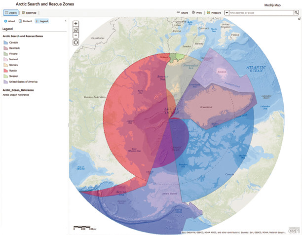
An example of an NGA public infosite service. This is an Arctic Search and Rescue Zones map, courtesy of NGA.
September 11, 2001
On September 11, radical Islamic terrorists hijacked four commercial airliners and flew one of them into the Pentagon and two others into the twin towers of the World Trade Center in lower Manhattan.
The fourth crashed in Pennsylvania when the passengers resisted and fought against their hijackers. In all some 3,000 innocent individuals lost their lives. President George W. Bush declared a global war on terrorism.
Two days later, NIMA welcomed retired Air Force Lieutenant General James R. Clapper Jr. as its third, and first civilian, director. He succeeded Army Lieutenant General James C. King.
Soon after his arrival the new director began to promote products that emerged from a variety of new initiatives, such as NIMA’s work on Chechnya in 2000.
This ambitious synthesis of source and image emerged during General King’s tenure and became known simply as geospatial intelligence. Among his newly created list of offices was the Office of Geospatial-Intelligence Management, whose mission was to provide the director, in his role as the geospatial intelligence functional manager, with the plans and policies to manage geospatial intelligence resources and a new system to be known as the National System for Geospatial Intelligence (NSG).
The first task of the new office was to develop and publish a series of formal communications that would comprise geospatial intelligence doctrine. The first of these, Geospatial Intelligence Basic Doctrine, appeared in July 2004.
The global war on terrorism and the events of September 11, dramatically changed the nature of NIMA’s priorities and products. Recognizing that new threats could occur at any time or place, Director Clapper decided both to make regional analytic overviews more robust, and to embed NIMA analysts throughout the combat support and intelligence community networks.

In November 2003 his concept of a unifying discipline and doctrine evolved into a new agency name: the National Geospatial-Intelligence Agency (NGA). The new name represented the maturation of a new discipline and the increased unification of NIMA’s parts.
Beyond A Name
Well before the tragedy of September 11, 2001, intelligence that depended upon the Earth’s physical attributes, as well as the art and science of interpreting that information, changed quietly but fundamentally. Combining most of the nation’s capable imagery and geospatial intelligence assets within NIMA in 1996 went beyond simply addressing problems of efficiency and economy. Rather, NIMA suddenly provided a critical mass of skills and technologies under a single mission umbrella that soon enabled the intelligence community to realize a significant step in the evolution of its craft and product.
Creating NGA acknowledged, in name and in practice, the confluence of every possible sort of imagery with geospatial, human, signals, electronic, and open source intelligence. This confluence created the innovative, sophisticated, and powerful product that NGA Director James Clapper formally christened GEOINT.
The change of name from NIMA to NGA had little to do with semantics. The nature of intelligence had changed forever. GEOINT demonstrated its unique ability to illuminate critical situations in ways that permitted both intelligent policy decisions and timely action. It confirmed ethnic cleansing atrocities in Kosovo through the latest in imaging and geospatial technology enhanced by an incomparable knowledge of culture and geospatial context.
From the cities hosting the Olympics to the Katrina disaster in New Orleans, Louisiana, NGA provided timely GEOINT products that allowed American authorities at every level to improve the quality and the timing of their security and emergency response. Even the 2006 White House report, in reviewing the Katrina disaster response and offering recommendations for improvement, applauded NGA’s timeliness during the crisis.
GEOINT offered a preliminary version of the same total picture for responders that the administration proceeded to recommend for the entire nation as a part of a standard plan to address major disasters.
While firmly rooted in a professional past that extends back to surveyors like the young George Washington and President Thomas Jefferson’s explorers Lewis and Clark, GEOINT has only recently emerged as a new synthesis of extraordinary technologies and valuable personal skills.
The NGA Gallery infosite: <a a="" c="organization&o=modified" "="" home="" http:="" nga.maps.arcgis.com="">For The Greater Good
The National Geospatial Intelligence Agency has the dual responsibility to learn daily from past GEOINT achievements and to practice—for the greater good—the powerful combination of technology and art the organization has created.
www.nga.mil/
The Mission
The National Geospatial-Intelligence Agency (NGA) delivers world-class geospatial intelligence that provides a decisive advantage to policymakers, warfighters, intelligence professionals and first responders.
Anyone who sails a U.S. ship, flies a U.S. aircraft, makes national policy decisions, fights wars, locates targets, responds to natural disasters, or even navigates with a cellphone relies on NGA. NGA enables all of these critical actions and shapes decisions that impact our world through the indispensable discipline of geospatial intelligence (GEOINT).
NGA is a unique combination of intelligence agency and combat support agency. The organization is the world leader in timely, relevant, accurate and actionable GEOINT. NGA enables the U.S. intelligence community and the Department of Defense (DOD) to fulfill the president’s national security priorities to protect the nation. NGA also anticipates its partners’ future needs and advances the GEOINT discipline to meet them.
NGA is the lead federal agency for GEOINT and manages a global consortium of more than 400 commercial and government relationships. The director of NGA serves as the functional manager for GEOINT, the head of the National System for Geospatial Intelligence (NSG) and the coordinator of the global Allied System for Geospatial Intelligence (ASG). In its multiple roles, NGA receives guidance and oversight from DOD, the Director of National Intelligence (DNI) and Congress.
NGA is headquartered in Springfield, Virginia, and has two major locations in St. Louis and Arnold, Missouri. Hundreds of NGA employees serve on support teams at U.S. military, diplomatic and allied locations around the world.
The National Geospatial-Intelligence Agency has a responsibility to provide the products and services that decision makers, warfighters, and first responders need, when they need it most. As a member of the Intelligence Community and the Department of Defense, NGA supports a unique mission set. We are committed to acquiring, developing and maintaining the proper technology, people and processes that will enable overall mission success.
Geospatial intelligence, or GEOINT is the exploitation and analysis of imagery and geospatial information to describe, assess and visually depict physical features and geographically referenced activities on the Earth. GEOINT consists of imagery, imagery intelligence and geospatial information.
NGA Sightings
Especially important, given the global interest in the Arctic of late, is the latest offering by the NGA of unclassified geospatial intelligence for the most northerly region of our planet.
The National Geospatial-Intelligence Agency launched a public website on September 2 that provides unclassified information about the Arctic. The public website supports efforts to strengthen international cooperation, better understand and manage resources responsibly, enhance quality of life in the Arctic and maintain valuable and vulnerable ecosystems.
The public site, located at nga.maps.arcgis.com, includes Digital Elevation Models (DEM) that provide 3D representations of the Arctic’s surface. The models, derived from NGA-sponsored DigitalGlobe commercial imagery sources, support land management, sustainable development, safe recreation, scientific studies, and domain-specific challenges inherent to directions, shape files and infographics.
A large, downloadable Pan-Arctic map includes multiple layers that allow users to focus on specific issues and information. Layers include search and rescue zones, ice extents, economic exclusion zones, bathymetric data, navigational and meteorological warnings, and potential energy sources.
NGA is working with the National Science Foundation and the White House Office of Science and Technology Policy to support the Arctic initiative by producing and contributing publicly-available products and data layers as they become available. NGA’s work also supports the Department of Defense Arctic Strategy and the safety of navigation in the air and on the seas.
NGA’s Arctic website shares the publicly-available online platform with its Nepal and Ebola relief sites, using Esri ArcGIS platform, hosted by Amazon Web Services.