
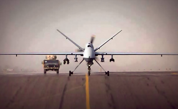
Intelligence, Surveillance and Reconnaissance (ISR) is by far the most prevalent application for Unmanned Aerial Systems (UASs).
Currently, the majority of ISR data from a UAS is transmitted by Common Data Link (CDL), line-of-sight directly to ground. There are, however, a number of missions where ISR transmission, beyond line-of-site over satellite, is most advantageous. As with most network designs, there is no one size fits all solution. There are pluses and minuses to both line-of-sight and beyond line-of-sight transmission of ISR traffic.
Line-of-site data transmission allows for very high data rates with relatively inexpensive and low-power transmission equipment on board. In fact, line-of-site, CDL video links can exceed 250Mb/s. Satellite links at such high speeds would be impractical on UAS platforms.
Of course, the drawback to line-of-sight communications is the need for line-of-sight. In many cases, to receive the video link a vehicle is deployed in theater. This practice has a number of obvious drawbacks not the least of which is the safety and security of the personnel manning the ground infrastructure.
The reliance of a ground infrastructure for CDL systems is very acceptable for certain applications. CDL links are widely deployed in battlefield operations and are very well suited to border patrol and first responder applications. CDL links, however, are limited if the mission is global or extends over a very wide geographic area.
Beyond line-of-sight data exfiltration systems using geosynchronous satellites require sophisticated tracking antennas and modems with Doppler-compensating modems. Furthermore, due to antenna size restrictions, the data rates available to transmit video off the aircraft are limited to about 15Mb/s. A number of new technologies being introduced are increasing theses data rates.
Some improvements in data rates are realized through new waveform and forward error correction techniques, and some are realized through new antenna technologies. Fortunately, the current limit in data rate does not preclude satellite communications for high-definition ISR missions.
Some high-definition codex can operate with as little as 2Mb/s with 6Mb/s being the most typical for HD video. Of course, the two things that make beyond line-of-sight communications most attractive are its independence from a terrestrial infrastructure and the global coverage available.
Certainly, exfiltrating ISR data is only half the story. In order for the video to be of any use, it has to be received by the people who need the information and in a very timely manner.
For missions with troops on the ground and an ISR covering a limited geographic region, CDL is an excellent solution. In the case where ISR data needs to be backhauled for further analysis, high-speed, ground-based, single channel per carrier satellite or even terrestrial links can be utilized. In some instances, the Global Broadcast Service (GBS) is used to bring ISR video to the field.

Currently, GBS is a one-way only system, but the desire and plan is to enable two-way communications. New satellite terminals are being developed with the ability to receive two independent DVB-S2 feeds. One DVB-S2 out-route would be used for the GBS service with the other as the out-bound for a two-way communications system.
Keeping the two systems independent is important for ease of transition and to maintain separate transmission security (TRANSEC) security domains. Integrating the GBS receive and the two-way communication in a single platform is vital in lowering the size, weight and power (SWAP) requirements of a communications package.
As airborne communications on the move (COTM) becomes more mainstream and technological advances continue to increase the data rates available off an airborne platform, direct to satellite ISR links will become more prevalent. The advent of High Throughput Satellites (HTS) with their global spot beam architecture will only speed the adoption rate.
The adoption of direct-to-satellite ISR will be driven by ISR platforms with a global mission. Existing terrorist networks are not limited to national boundaries or geographic regions. Furthermore, conflicts can quickly arise halfway around the world. UAS platforms which can operate on a global scale are ideal for these quick response ISR missions.
Security becomes increasingly complex in a system which is global in nature and utilizes a broadcast technology such as satellite as its transmission medium. Seamless hand-off of a UAS from one satellite coverage area to another is one thing. Seamless hand-off of a UAS under TRANSEC cover is another.
For global networks in which one operator controls the entire ground infrastructure, a solution for global TRANSEC cover has been designed and implemented. The challenge now is to extend that TRANSEC capability to include the global footprint of HTS secure, commercial service.

Although line-of-site backhaul will continue to play a dominant role in ISR missions with the pieces quickly coming into place, the use of direct to satellite exfiltration will grow dramatically. The flexible, ubiquitous coverage, and the independence from a terrestrial infrastructure that satellite communications offers, bring too many compelling reasons not to move many ISR missions to satellite. Enhancements in waveform, security and antenna technologies are rapidly dispelling objections against satellite. These are fundamentally the same driving factors which have brought satellite COTM to commercial aircraft.
About the author
Karl Fuchs serves as Vice President of Technology for iDirect Government Technologies (iGT); kfuchs@idirectgt.com.
Editors note: Images for this article were provided by iGT.
* * * * * * * * *
iGT AiMS High
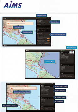
Airborne In-flight Monitoring System (AIMS) is iGT’s solution for customers to view satellite information with respect to a moving aircraft while in flight.
The software, which is loaded onto a PC, communicates with the iDirect modem, as well as the Antenna Control Unit (ACU) to display the real-time position of the aircraft and allows a user to quickly see when the aircraft will leave one satellite coverage footprint and enter another.
With AIMS, an operator is able to quickly determine the position of the aircraft and whether or not a communications interruption might occur due to switching satellite footprints.
The operator has the ability to manually switch to an available network, or view a countdown timer before the automatic beam switch occurs.
Through the Graphical User Interface (GUI), a beam information window is provided that displays information on all the beams for the configured modem.
AIMS provides the option for a user to log flight statistics into a KML file format for future analysis. These flight statistics are logged every two minutes and include iDirect Modem and ACU parameters.