
Indo-Pacom Commander Highlights U.S. Army’s Regional Contribution
During the 2025 Land Forces Pacific Symposium and Exposition in Honolulu, the U.S. military’s senior leader in the Indo-Pacific area of responsibility discussed ways the Army contributes to the joint force’s overall mission throughout the region.
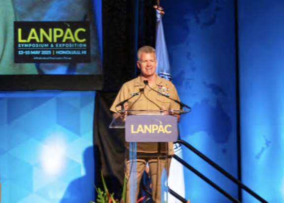
Navy Admiral Samuel J. Paparo, commander of U.S. Indo-Pacific Command, said “fires” or weapons systems that strike targets are the capability he most needs.
“The ability to deliver fast, accurate and lethal fires across domains is fundamental,” he said.
Paparo referenced China’s potential invasion of Taiwan as an example, noting that U.S. maritime and air superiority aren’t necessarily needed to prevent an invasion. Rather, the joint force needs the capability to deny China’s use of the Taiwan Strait.
“And the Army’s fires capability, integrated with the … joint force, is essential to deny that zone by imposing devastating costs,” he added.
Paparo also said that, over the past nine years, the Army has risen to meet a challenge issued by a previous Indo-Pacom commander to forge a capability to “Sink ships, neutralize satellites, shoot down missiles and deny the enemy’s command and control. The Army responded decisively with the creation of multidomain task forces.”
He added that there are currently Multi-Domain Task Forces (MDTFs) in the field bringing land-based capability to oppose the enemy’s command, control, communications, computers and information systems’ surveillance, reconnaissance and targeting capabilities.
“This fundamentally alters the strategic calculus in the contested environment,” Paparo said, adding that the MDTF capability allows the joint force to place fires and effects “precisely at the time and the place of our choosing.”
Paparo also praised the Army’s short-range, ballistic Precision Strike Missile capability, calling it “a game-changer that fundamentally alters China’s risk calculus; this is a matter of record.”
He noted that the missile system is capable of potentially neutralizing numerous enemy targets before any kinetic conflict begins.
“These capabilities—along with space, cyber and electronic warfare—operate from key terrain in the first island chain and near strategic maritime choke points, creating... persistent and lethal effects,” Paparo said, adding that he considers the Army’s fires capability to be the most valuable and lethal asset in the region.
Paparo also spoke about the command’s air and missile defense components. He said the missile threat posed by China and North Korea is growing in “both quality and sophistication,” and that the command’s AMD needs to be resilient, adaptive and responsive to evolving challenges. He also said interoperability with allies is key.
“By connecting these defense systems, sharing intelligence and coordinating responses, we create a common operating picture and then, accordingly, a combined defense shield,” Paparo said.
He also discussed the Army’s role in sustainment throughout the region, stating that effective sustainability is “existential.”
Paparo said integrating artificial intelligence into the process is “revolutionizing sustainment” as it allows his command to anticipate requirements in all classes of supply — fuel, ammunition and missiles.
The admiral said the Army provides the “backbone” of the joint force’s ability to sustain combat power throughout the region, and its role in theater-wide sustainment cannot be overstated.
He said the challenges in the Indo-Pacific region are “formidable but not insurmountable. The Army’s contributions to joint conflicts are transformative and inspiring, but we all must do more—and we need to do it now.”
uAvionix debuts Trakr
uAvionix this month announced the launch of Trakr, a new suite of hardware and services that extends the company’s FlightLine airspace surveillance platform to include real- time monitoring of customer-owned drone operations alongside ADS-B data from aircraft.
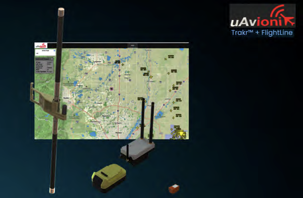
By integrating Trakr’s UAS-specific position feeds with FlightLine’s ADS-B aircraft surveillance, uAvionix now delivers a complete picture of low-altitude airspace for operators conducting critical missions such as Drone as First Responder (DFR), infrastructure inspection, wildfire response, range managers, and beyond.
As low-altitude airspace becomes increasingly populated with UAS, operators and airspace managers face significant challenges in maintaining situational awareness. FlightLine has long provided FAA- trusted ADS-B surveillance. However, the absence of assured, real- time drone tracking has left critical blind spots for UAS operators— particularly in BVLOS and multi-drone environments. Remote ID technologies offer limited range and are often not suitable for enterprise operations.
With the introduction of Trakr, uAvionix provides operators with a private UAS tracking ecosystem integrated with the FlightLine platform for the display and monitoring of UAS operations. The Trakr device, a compact, low-SWaP transmitter affixed to each drone, broadcasts real-time GPS position over the 915 MHz ISM band. The signal is received by either a permanently installed TrakrStation or the portable, battery-powered TrakrStationLTE, and transmitted to the cloud-based FlightLine portal.
Read more at this direct link...
Saab signs MoU with ICEYE
Saab and ICEYE, recently signed a Memorandum of Understanding (MoU) to cooperate on the development and integration of advanced space-based radar data in Saab’s command and control (C2) systems.

This strategic cooperation aims to integrate ICEYE’s cutting- edge SAR technology solutions into Saab’s command and control systems, enhancing tactical decision-making and situational awareness in defence.
Space-based sensor capabilities are becoming crucial for modern militaries, providing access to critical information in challenging environments. This cooperation intends to deliver tangible value to customers by integrating ICEYE’s enhanced situational awareness, long-range targeting, and improved tactical decision-making capabilities with Saab’s command and control systems.
The MoU lays the foundations with the initial focus on investigating and demonstrating integration for multi-domain operations. The benefits would enable advanced space situational awareness (SSA) and critical infrastructure protection capabilities, providing valuable insights for both civilian and military authorities in times of peace, the grey zone or conflict.
“Saab’s integration with ICEYE data will provide real-time, high-resolution imagery through clouds and darkness, enabling comprehensive surveillance and reconnaissance for faster, even more informed decisions, in complex operational environments,” said Carl-Johan Bergholm, Senior Vice President and Head of Saab’s business area Surveillance.
Uk-made space system to help protect military satellites
UK-made tech will help the military monitor space ollowing a new £65 million deal. The Borealis command, control and data processing system will help the UK military and the UK Space Agency to better monitor and protect satellites, through new software which compiles Uk-made space system to heLp pRotect miLitaRy sateLLites and processes data from multiple sources, more quickly, to monitor space.

The £65 million deal with CGI UK, will support around 100 skilled jobs in Leatherhead, Reading and Bristol, boosting the UK’s space capabilities and delivering on the Government’s Plan for Change.
The new technology will provide UK military with a better understanding of the Space Domain, improving military commanders decision-making process and supporting operations, both at home and overseas.
Under the five-year contract, Borealis will provide software for the National Space Operations Centre, which develops and operates the UK’s space surveillance and protection capabilities. It will be a unique, UK-made system which support military operations around the world.
Borealis will enhance the UK’s ability to monitor and protect crucial space assets, which underpin the UK’s security and prosperity, enabling us to navigate the oceans, keep our military personnel safe, monitor the climate, and forecast the weather.
Read more at this direct link...
DIU solicitation: CUAS Low Cost Sensing Challenge
The Defense Innovation Unit (DIU), in collaboration with the U.S. Northern Command (USNORTHCOM), seeks to identify solutions for scalable, cost-effective, unmanned aircraft system (UAS) detection, identification, and tracking.
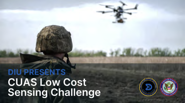
This challenge aims to enhance the DoD’s counter-UAS (CUAS) capabilities while addressing cost and scalability limitations associated with traditional radars, optical sensors, and radio frequency detection systems.
DIU Director, Doug Beck, said, “This work will significantly enhance our ability to detect and track threats, and will help our NORTHCOM teammates secure the homeland.”
DIU Lead for Counter UAS, Matthew Way, said, “DoD needs more options for low cost cUAS sensors that can augment our more exquisite capabilities to provide earlier warnings and indicators,” said Way. “We understand there may be trade-offs in detection range and accuracy to drive down costs versus positively enabling a distributed sensing concept.”
Establishing a layered domain awareness network from seabed to space to detect and track threats approaching North America is critical to immediate and future mission requirements, because you can’t defeat what you can’t see,” said General Guillot at the Senate Hearing on the Posture of NORTHCOM and SOUTHCOM for FY 2026
A team of subject matter experts will evaluate applicants and select up to 10 finalists. This group of finalists will receive a portion of the overall funding to help cover their participation in NORTHCOM’s Falcon Peak exercise in September of 2025. The top performing vendors at Falcon Peak will compete for the remaining prize funding.
Learn more at this direct infolink…
Synspective + SATIM launch Object Detection and Classification (ODC ) solution
Synspective Inc. has launched the firm’s Object Detection and Classification (ODC) solution that is designed to enhance the accuracy and reliability of monitoring vessels and aircraft—this solution overcomes the limitations faced by traditional monitoring systems, offering scalable and cost-effective wide-area security.
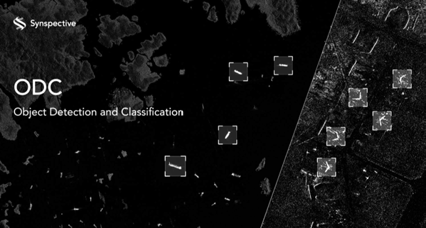
Monitoring maritime and land domains faces significant challenges due to the vast areas and dynamic nature. Optical satellites have difficulty with cloud cover and darkness, while ground-based systems and patrols face limitations in coverage and high operational costs. Recognizing these hurdles, Synspective’s ODC solution delivers a persistent surveillance capability, ensuring security and operational efficiency around the clock, regardless of weather conditions or time of day.
Synspective’s ODC leverages advanced SAR data and analytics to provide timely and precise insights into the presence, location, and type of vessels and aircraft. This is supported by our plan to deploy a constellation of more than 30 StriX SAR satellites by 2030, which will significantly enhance monitoring frequency and coverage capabilities.
The company’s collaboration with SATIM, a leader in AI-based Automatic Target Recognition (ATR) on SAR imagery, integrates proven algorithms into Synspective’s analytical platform, ensuring reliable detection and classification of target objects. This platform is designed for flexibility and future advancements, with plans to extend detection capabilities to a broader range of objects.
Learn more at this direct infolink...