With its own waters largely depleted, China’s fleet of fishing vessels has journeyed abroad over the past several years to exploit more plentiful marine life. Although China maintains that its fleet abides by international laws and regulations, claims of indiscriminate fishing, resource depletion, and aggression against other vessels and authorities have followed the fleet.
Most recently, the Chinese fleet was spotted outside the exclusive economic zone (EEZ) surrounding the Galápagos Islands. HawkEye 360 quickly initiated monitoring to improve situational awareness of fleet activity. The company’s results reveal Chinese vessels attempting to hide by deactivating Automatic Identification System (AIS) tracking hundreds of times. Hawkeye 360 also discovered evidence of illegal fishing, with multiple instances of dark vessels operating within the Galápagos EEZ.
Background
In late July 2020, the Ecuadorean Navy discovered a fleet of roughly 260 Chinese fishing vessels just outside the EEZ surrounding the Galápagos Islands.

Although the Chinese fleet was in international waters, global concern around the incident grew. Deemed a “living museum and showcase for evolution” by UNESCO, the Galápagos Islands are home to a diverse range of geological features, wildlife and marine life, including several rare and endangered species. Chinese fishing vessels have been identified in the seas near the Galápagos over the past several years as they search for new fishing areas and, in 2017, the Ecuadorean Navy captured a Chinese fishing vessel within the Galápagos marine reserve carrying 300 tons of marine wildlife — including endangered species.
This is not the first time China’s fishing fleet has raised international tensions. With its own waters fairly depleted, China’s “dark fleet” has surfaced further and further abroad to fill its nets. Reported incidents with China’s fishing fleet are often accompanied by claims of indiscriminate fishing and aggression that have prompted some critics to call it “more than just a commercial concern; it acts as a projection of geopolitical power on the world’s oceans.”
Monitoring is essential for a country to properly police its EEZ and prevent encroachment by foreign entities. However, the vast ocean expanses make it incredibly difficult to find vessels that may be participating in illegal fishing — especially when a fleet of vessels turn off their AIS, as has been reported about the Chinese fishing fleet.
The EEZ for the Galápagos Archipelago encompasses 700,000 square kilometers. This area is larger than the state of Texas or greater than Spain and Portugal, combined. Effectively patrolling this massive region using traditional coast guard or airplane-based observation is nearly impossible, making it easy for a fishing vessel to “go dark” and cross over EEZ boundaries in pursuit of richer catches.
Revealing New Insights
HawkEye 360 delivers a unique method to gain maritime awareness through radio frequency (RF) geospatial intelligence. HawkEye 360 monitored the Galápagos Islands over the summer of 2020 to supply a fresh set of eyes on the Chinese fishing fleet behavior. The company routinely collected and analyzed a variety of maritime RF signals, such as X-band marine navigation radar, to increase visibility beyond just AIS.
The Chinese fleet first approached the Galápagos around the start of July and remained in the region for two months before leaving the end of August. The composite data image below displays all AIS vessel traces, showing the intensity of RF activity as the fleet swarmed along the southern edge of the EEZ boundary (see Figure 1).

The bulk of the fleet appeared careful to not cross the EEZ boundary, instead deciding to come as close to the line as possible without violating international law. Although it’s technically not illegal to fish in this manner, such intensive and large-scale fishing by the fleet pushes the bounds of proper behavior, stripping adjacent waters of many types of marine life.
It’s even more important to consider what can’t be seen. This is especially true when searching for vessels that may not be transmitting AIS signals. HawkEye 360’s SEAker® analytics identified gaps in the AIS records where vessels seemed to disappear for eight or more hours. The next graphic displays all of these disappearances, grouped into half-month periods through July and August (see Figure 2 on the next page).
As the Chinese fleet entered the region, the preponderance of dark tracks rapidly increased, with Chinese-flagged vessels representing 87 percent of all gaps by the end of July. Likewise, when examined by vessel type, fishing vessels composed 90 percent of all gaps.
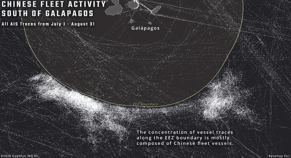
Figure 1.
Chinese fishing vessels move sporadically, remaining in the same vicinity for as long half a day, then rapidly traveling 50 km to a new position within a few hours, making it very difficult to track without consistent AIS records.
To piece together what happens during tracking gaps, HawkEye 360’s satellites located vessels by looking for other common marine vessel signals. HawkEye 360’s RFGeo™ product identifies and geolocates a wide variety of RF emissions, both at sea and land, providing a new dimension of knowledge.
During a six-week period from mid-July to the end of August, we compared our geolocations against AIS data to filter out vessels that were routinely reporting their locations. The remaining hundreds of geolocations indicated previously unknown vessel positions. (See Figure 3 two pages ahead).
Of greatest concern, HawkEye 360 discovered multiple instances of RF activity within the EEZ immediately adjacent to the heart of the Chinese fishing fleet. None of these locations correlated with AIS records for the entire day when they were detected.
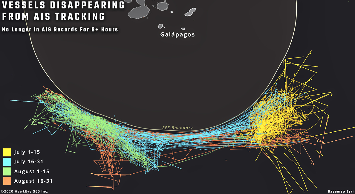
Figure 2.
Although this could be other types of vessels engaged in legitimate activity, these signals may be evidence of dark Chinese vessels crossing into the EEZ to conduct illegal fishing. This is where RF geospatial intelligence serves value in pinpointing suspicious behaviors for authorities to conduct further investigation.
HawkEye 360 leveraged its insights to collaborate with partner Airbus Defence and Space Intelligence in a joint RF and synthetic aperture radar (SAR) co-collection to perform a Multi-INT analysis. On August 1, HawkEye 360 collected RF signal data multiple times throughout the day. Airbus tasked their TerraSAR-X satellite to capture a large scale ScanSAR radar image. Radar imaging has the benefit of seeing through poor weather conditions (see Figure 4 two pages ahead).
Airbus’ satellite-based vessel detection chain extracted 58 vessels locations from the SAR image and provided estimated size and heading for each vessel. Comparing these locations against +/- 60 minutes of AIS data matched 16 vessels to AIS tracking, reinforcing the many gaps in the AIS record.
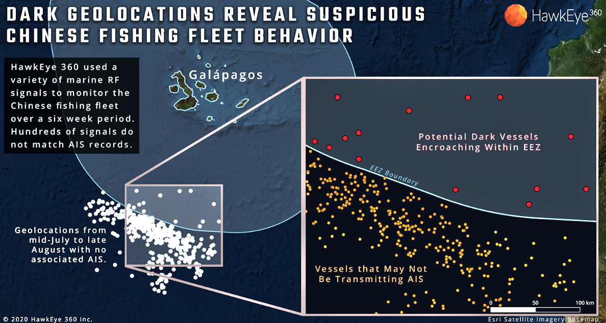
Figure 3.
Item A in Figure 4 displays a large cargo vessel that has a strong AIS record and appears to be passing through the EEZ legally. In contrast, Airbus located another vessel within the EEZ that HawkEye 360 could not associate with any AIS, raising suspicion of that vessel’s activity.
Item B shows a grouping of four mystery vessels, all within 4-6 kilometers of each other. None of these vessels matched +/- 60 minutes of AIS records. But seven hours before the SAR collection, HawkEye 360 detected VHF radio communications between two vessels at this same place.
There were 46 vessels that transmitted AIS at some point within a 50 km radius. But after examining all these travel records, it seems likely that the four mystery vessels appearing in the image were dark for extended periods, perhaps even the entire day.
Item C potentially displays two vessels alongside each other. Although resolution of the SAR image makes it difficult to confirm, this could be an instance of transshipment, where supplies or fish are being transferred from one vessel to another.
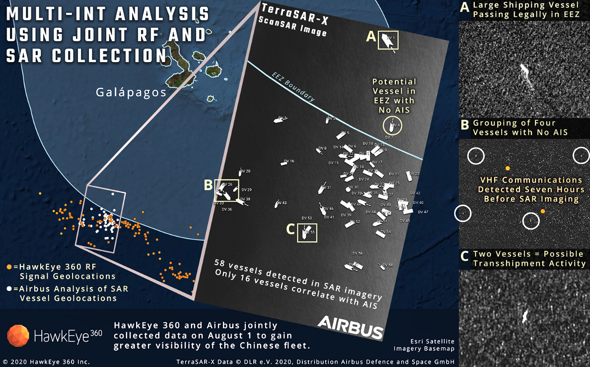
Figure 4.
The Takeaway
To an observer using AIS alone, it would likely appear that the Chinese fleet outside the Galápagos Islands was respecting international law.
However, large gaps in AIS records create opportunity for vessels to engage in illegal behavior without notice.
HawkEye 360’s geolocations of vessel activity reveal many instances of suspicious vessel behavior, including evidence that many vessels in the Chinese fleet stopped broadcasting AIS and may have encroached deep into the Galápagos EEZ. Using our RF data to tip and cue a SAR co-collect with Airbus, we were able to paint a more comprehensive picture of fleet activity.
With RF analytics, authorities monitoring the Galápagos — and those protecting valuable resources elsewhere — can see a more complete picture of maritime activity, allowing them to act quickly and confidently. Bringing these previously hidden activities to light provides a powerful deterrence to further illegal behaviors anywhere across the globe.
https://www.he360.com/