
Colonel Cooley is responsible for a multi-service, multinational systems directorate which conducts development, acquisition, fielding and sustainment of all GPS space segment, satellite command and control (ground) and military user equipment. The $32 billion GPS program, with a $1 billion annual budget, maintains the largest satellite constellation and the largest avionics integration and installation program in the Department of Defense.

Colonel Cooley was commissioned in 1988 through Air Force Reserve Officer Training Corps and graduated from Rensselaer Polytechnic Institute, Troy, New York, with a degree in mechanical engineering. In addition to his continued technical education, which culminated in a doctorate of philosophy, engineering physics, Colonel Cooley’s professional military education includes Squadron Officer School, Air Command and Staff College and National War College.
Colonel Cooley’s assignments include System Program Director for operational command and control programs, including the Air and Space Operations Center; Program Manager, Air Force Distributed Common Ground System; Defense Sector Program Manager, Office of Security Cooperation—Afghanistan, Kabul, Afghanistan; Program Element Monitor for Military Satellite Communications at the Pentagon; staff officer at the Warrior Preparation Center, Einsiedlerhof Air Station, Germany; Branch Chief, Semiconductor Laser Branch, Directed Energy Directorate, Air Force Research Laboratory, and Commander Phillips Research Site and Materiel Wing Director, Space Vehicles Directorate, Kirtland AFB, New Mexico.
MilsatMagazine (MSM)
Colonel, a good place to start would be to learn what education and training was required to enter the satellite environment within the USAF after your graduation from college? Was there something readily identifiable that pointed your Air Force career into this crucial field of endeavor?
Colonel Cooley
I was very fortunate because after graduating from Rensselaer Polytechnic Institute I attended graduate school while working at Sandia National Labs and then began my Air Force career in the Air Force Research Laboratory working on space technologies.
This spurred my interest in physics, so I pursued a PhD in physics while active duty at the Air Force Institute of Technology. From there I had a variety of assignments—some directly related to space and some not—but all of the experience I gained has helped prepare me for the leadership positions I’ve held. Although every experience is important, I have to say that my technical education forms the foundation of my understanding and career success.
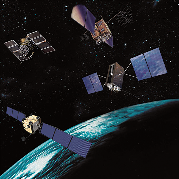
An artistic rendition of GPS II, IIR, IIF and III over the Earth. Image is courtesy of SMC.
MSM
The Global Positioning System (GPS) recently achieved 20 years of on-orbit service—please define what GPS is as a Global Navigation Satellite System (GNSS).
Colonel Cooley
The GPS Directorate is proud to celebrate 20 years of on-orbit service, marking the 20th anniversary of the declaration of initial operational capability (IOC) on 8 December 2013. The best way to think about GPS is as a global utility—GPS provides high-quality, precise positioning, navigation and timing (PNT) for the military and civilian users, all the time and at every place around the globe and in space. This is what it means to be a Global Navigation Satellite System. The men and women of the GPS Directorate take great pride in providing a capability that is the GNSS “Gold Standard” because the performance has met or exceeded our commitment to all users since 1993 and is available free of charge to all nations.
MSM
Colonel Cooley, your responsibilities for, arguably, one of the most crucial, global constellations would seem to be massive in scope. Would you please explain your duties and those of your command to our readers?
Colonel Cooley
First let me say that I don’t do any of this myself—I have a terrific team in the GPS Program Office and I get a lot of help from a terrific team at Space and Missile Systems Center. As the GPS Program Director, I am responsible for developing, producing, and maintaining the PNT gold standard that is GPS.
As GPS is crucial to both military and civil users, I need to understand and support each community’s needs. The Standard Positioning Service Performance Standard (SPS PS) and the Precise Positioning Service Performance Standard (PPS PS) for civil and military users, respectively, help to communicate to a diverse audience what they should expect and to build confidence in the PNT service promised by GPS. To meet these commitments, it takes careful and constant program management of the GPS Enterprise—balancing cost, schedule, and performance—and a passion for this important mission.
MSM
The GPS IIF series built by Boeing brings one L1, two L2 and a new L5 frequency into play. What are these frequencies used for?
Colonel Cooley
For reference, the GPS IIR-M series introduced one new L1 and two new L2 signals, while GPS IIF introduced the new L5 signal. All of these signals are part of the GPS IIF navigation payload and provide information including the GPS date and time, satellite health, satellite ephemeris (for individual satellite positioning), and almanac information (for information on other satellites in the constellation).
The L1 frequency carries the L1 C/A code for civil users, and the L1 P(Y) code and L1 M-Code for military users. The L2 frequency carries the first modernized civil signal, L2C, and the L2 P(Y) code and L2 M-Code for military users. Finally, the L5 frequency carries the newest modernized civil signal. The L1 C/A with the addition of the L2C civil signal enables all GPS customers to be true dual-frequency users, which allows for very precise ionospheric corrections which greatly improves the PNT accuracy. The new L5 signal will be used for Federal Aviation Administration safety-of-life requirements.
MSM
There are currently 31 satellites in the GPS constellation. From Block II to Block IIF, what iterative improvements have been made for today’s generation of GPS satellites? What new services are provided?
Colonel Cooley
Currently, there are 31 satellites available for customer use. Each new generation of GPS satellites provides enhanced capability over the previous generations. Accuracy improvements have been achieved through advancements in atomic clock technology. Space vehicle design life has been steadily increased from 7.5 years with GPS IIA to 12 years with GPS IIF. The increase in the number of navigation signals available to users is one of the most significant upgrades. The GPS IIR satellites provide the legacy standard service (L1 C/A) for civil users and the precise service (L1- and L2- P(Y) code) for military users.
The GPS IIR-M satellites provide the legacy signals, plus the second civil signal, L2C. GPS IIR-M also provides M-Code on L1 and L2 for military users; M-Code enables operations closer to jammers and under trees and is much more secure than the legacy code. The latest GPS space vehicle, GPS IIF, provide a new operational third civil signal (L5) that benefits commercial aviation and safety-of-life applications.
In addition to an increased number of signals, GPS IIF also provides more than twice the legacy power levels, has an increased design life of 12 years and three highly accurate and stable atomic clocks per satellite. Following GPS IIF, the next-generation, in-production GPS III satellites will provide a fourth civil signal, L1C, which provides the first internationally interoperable signal. GPS III will provide even more signal power and greater resistance to jamming and spoofing, increases the longevity of the constellation with a 15-year design life, and provide search-and-rescue capabilities.
MSM
There are challenges to GPS from other nations around the world: Europe’s Galileo, Russia’s GLONASS, China’s BeiDou, India’s GAGAN. Why so many differing systems when all, basically, provide similar information? Why the challenges to the U.S.-developed constellation?
Colonel Cooley
The increase in foreign satellite navigation systems mentioned in your question (also Japan’s Quasi-Zenith Satellite System, QZSS) stems from the unparalleled success of GPS around the globe. For the United States, GPS serves as a critical part of our nation’s infrastructure by supporting transportation, communication, public safety, agriculture, financial systems and other key areas while also bolstering the economy.
In many cases, foreign governments see these benefits and wish to provide the critical infrastructure support via their own systems. Some foreign providers intend to provide a global navigation service very similar to GPS (Galileo and GLONASS). In other cases, the navigation systems are regional and provide capabilities such as improved accuracy in challenging urban environments (QZSS, BeiDou and the India Regional Navigation Satellite System, IRNSS).
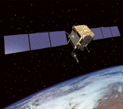
Artistic rendition of GPS Block III.
Image courtesy of USAF SMC.
MSM
Given the various GPS constellations, are there any considerations underway for cooperative linkages between systems with other nations?
Colonel Cooley
Yes, under the guidance of 2010 National Space Policy, the GPS Directorate actively engages other nations to enhance PNT capabilities through international cooperation. Specifically the 2010 National Space Policy states, “Engage with foreign GNSS providers to encourage compatibility and interoperability, promote transparency in civil service provision, and enable market access for U.S. industry.”
Furthermore, this policy also states that the United States may use foreign satellite navigation services to augment and strengthen the resiliency of GPS. The GPS Directorate chiefly supports this task by participating in the International Committee on GNSS (ICG) established in 2005 under the United Nations to promote cooperation on matters of mutual interest to international, civil satellite-based PNT.
MSM
What makes the U.S. GPS system more desirable than other nation’s offerings?
Colonel Cooley
The proven, reliable, and unparalleled performance of GPS makes it a very desirable GNSS system. Simply put, GPS embodies the only global navigation satellite system that has provided continuous operations since satellite-based navigation began. For over twenty years, GPS has provided high-quality PNT, referred to as the gold-standard of PNT.
In addition, GPS makes a clear promise to its users in the Standard Positioning Service Performance Standard (SPS PS) on key parameters including accuracy, availability, and reliability. Transparency allows GPS customers to plan and create innovative solutions for over a billion users on a daily basis. Lastly, the current comprehensive modernization underway for GPS gives customers confidence that GPS will continue to provide gold-standard PNT service for the foreseeable future.
MSM
How can the Air Force ensure the survivability and security of GPS signal frequencies for use by U.S. and Allied military and government entities, given their critical signal needs, which are being continually assaulted by RF interference and attempted hostile data interdictions?
Colonel Cooley
We actively monitor and coordinate with the various regulatory bodies that govern the usage of the electromagnetic spectrum to protect the survivability and security of GPS for the future. In the United States these include both the Federal Communication Commission (FCC) for commercial users and the National Telecommunications and Information Administration (NTIA). Internationally, the regulatory body is the International Telecommunications Union Radiocommunication Sector (ITU-R). These organizations exist to prevent electromagnetic services from interfering with one another by managing frequency allocations.
In addition to protecting the spectrum, the USAF continually updates its space systems, including GPS, to ensure that US space systems are at the highest state of readiness possible at all times. Key upgrades such as higher power, more signals, and advanced receiver techniques in the GPS user equipment (e.g., adaptive antennas) provide increased protection to the future of GPS.
The USAF conducts extensive on-orbit and ground testing to mitigate risks prior to operational use of GPS and other space systems to ensure there are no adverse impacts to currently fielded military and civil GPS receivers. Furthermore, the GPS program has made significant investments to a modernized GPS system that features higher power from space, military receivers more resistant to jamming, and innovative software development to increase resistance to spoofing.
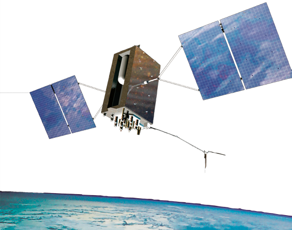
Artistic rendition of GPS III, courtesy of USAF SMC
MSM
The primary role of government is the security of a nation’s citizens yet unwise budget cuts continue by those who do not understand that. How do you manage to ensure continuing financial and personnel support for the GPS Directorate?
Colonel Cooley
The Air Force works closely with the Department of Defense and Congress to ensure decision makers have the information needed to properly and prudently allocate resources. The GPS Directorate and our industry partners work tirelessly to reduce cost whenever possible yet continue to provide the Gold Standard PNT service our military and nation expects.
MSM
There are a number of commercial companies working diligently on small satellite development, from Earth Observation to ISR and other communication projects. Do you see a time when the Air Force would contemplate the use of several satellites to further MAG data acquisition and delivery? Could small satellites ever play a role within GPS missions?
Colonel Cooley
The Air Force has identified and studied a range of alternative GPS architectures offering the potential of cost reductions. The two most promising alternatives to reduce costs are saving on launch cost via a dual launch capability, and a smaller navigation-only (without the NDS payload) satellite sometimes called a NavSat. While these alternatives have potential, both require up-front investment with savings years away. These alternatives, along with several others, will continue to be a potential area of interest for the Air Force.
MSM
As you review your career to date, what project, or projects, truly bring a sense of satisfaction to you?
Colonel Cooley
Without a doubt, my current position with GPS is the most satisfying. Although I’ve had a terrific career and opportunities that I would never have dreamed possible, the GPS mission and team are truly exceptional. There is a passion and energy for this important mission that the entire GPS Directorate shares. Having the opportunity to bring a capability that billions of people around the globe rely on every day is really remarkable. I am thrilled to be a part of this terrific program!
* * * * * * * * *
An Anniversary Of Note
The Global Positioning System (GPS) Directorate celebrated the 20th Anniversary of achieving Initial Operational Capability (IOC) for GPS late last year.
In 1973, the Navstar Global Positioning System Joint Program Office (JPO), headed by then-Colonel Bradford Parkinson, developed the GPS architecture and initiated efforts to field a prototype system to prove the concept of space-based global navigation would work. Since that time, GPS has evolved from an idea, to a prototype, to a global utility. It continues to evolve, with modernization bringing forth new capabilities for the 21st century.
Since the launch of the prototype Block 0 satellite June 22, 1977, GPS has provided high quality navigation signals to suitably equipped users across the globe. Beginning in 1978, after the first four developmental Block-I satellites were launched, GPS started to provide full four-dimensional positioning, navigation, and timing (PNT) services to military and civilian users on a limited, but worldwide, basis. By 1985, the seven remaining developmental Block I satellites were launched to expand the availability of PNT services around both time and space. The second stage of GPS began February 14, 1989 when the first operational Block II satellite was launched into orbit. More Block II and Block IIA launches followed rapidly thereafter until, December 8, 1993, United States Air Force Space Command (AFSPC) declared IOC for GPS when a grand total of 24 Block I and Block II/IIA satellites were operating in their individual orbits and providing the Standard Positioning Service (SPS) to civilian users and the Precise Positioning Service (PPS) to authorized military users.
After IOC, additional Block IIA satellites were launched to fully populate the baseline operational constellation of 24 slots arranged in six orbital planes—the remaining developmental Block I satellites continued providing high quality navigation signals even though they were not part of the baseline operational constellation. Once system testing was complete, AFSPC declared Full Operational Capability (FOC) for the GPS constellation April 27, 1995, signifying the system met all requirements with 24 operational Block II/IIA satellites in their assigned orbital slots and providing both the military PPS and the civil SPS.
Today, the GPS constellation remains healthy, stable and robust with 31 operational satellites on-orbit broadcasting the PNT services 24 hours a day, 7 days a week, 365 days a year. In the 20 years since IOC, GPS has never failed to deliver on the global PNT service commitments made by the Department of Defense in the PPS Performance Standard (PPS PS) and in the SPS Performance Standard (SPS PS)—both of which trace directly back to the original Global Positioning System (GPS) Standard Positioning Service Signal Specification (SPS SS) which was officially promulgated on December 8, 1993 by the Assistant Secretary of Defense for Command, Control, Communication and Intelligence (C3I) as the formal document which defined IOC. Amazingly, though many Navstar satellites have been launched and been decommissioned over the past 20 years, four of the original Block IIA satellites which made up the IOC constellation (SVN-23, SVN-26, SVN-34, and SVN-39) are still operating and providing reliable PNT services as of this 20th Anniversary of IOC.
GPS has grown to become a vital worldwide utility serving billions of users around the globe. GPS multi-use PNT services are integral to the United States global security, economy, and transportation safety, and are a critical part of our national infrastructure. GPS contributes vital capabilities to our nation’s military operations, emergency response, agriculture, aviation, maritime, roads and highways, surveying and mapping, and telecommunications industries, as well as recreational activities. It is not an overstatement to say GPS is fundamental to today’s technical infrastructure and culture. GPS provides the ‘winning edge’ to our warfighters and allies by delivering premier space-based PNT services to the nation and the world.
For more information regarding the GPS Directorate, access http://www.losangeles.af.mil/library/factsheets/factsheet_print.asp?fsID=5311&page=1.