Whether providing food and medical assistance to stricken communities following a natural disaster, or co-ordinating a countywide search for a missing child, in times of crisis, first responder emergency teams need to swiftly mobilize and co-ordinate resources.

Extreme weather conditions are dominating the news—bringing floods that are devastating the coastline of the United Kingdom, to rampaging forest fires in California. There are earthquakes and volcanoes around the Ring of Fire, typhoon devastation in the Asia-Pacific region and starvation in Africa caused by drought and political upheaval. Emergency teams must be able to react quickly and decisively to save lives and property around the globe.
Somewhere in the world, each day of each year, there seems to be a state of emergency that requires efficient and rapid collaboration among law enforcement and environmental agencies, national and regional transportation authorities, ambulance and fire services as well as other trained entities, all doing their best to alleviate suffering. While we watch these real-life dramas unfold on our TV screens, thousands of people working for international, national and local emergency services and relief organizations struggle to help people in often highly complex and usually hazardous environments.
Achieving true interoperability and optimizing highly effective communication among public safety agencies and first responders has always been a challenge. This quite dramatically came to public consciousness in the wake of the tragic events of 9-11. Now, more than a decade later, while lessons have been learned and improvements have been made, frustrations persist over poor communications and interoperability during almost any natural disaster or crisis that requires inter-agency response, whether on a massive scale such as a tsunami, or even in the case of rapid co-ordination to search for a missing person.
Thankfully, there are now communication systems that can provide real-time situational awareness to first responders. These systems have paved the way for the development of advanced technologies in the global first responder command, control, communications and intelligence (C3i) and emergency response market.
Analysis from Frost & Sullivan (http://www.defense.frost.com), Assessment of Global First Responder C3i and Emergency Response Market, reveals that the emergency communications market represented revenues of $50.41 billion in 2012 with estimates of $131.62 billion in 2019. North America accounts for the largest share of the market, followed by the countries of Asia Pacific.
Heightened awareness of terrorism further highlights the crucial need for law enforcement, fire and emergency medical services to be equipped with the technologies that will help them ensure public safety.
Traditionally, first responders have relied on radio networks that require microwave-based transmission systems and a plethora of masts and repeaters. Mobile telecommunications networks have been used to provide supplementary help to emergency teams when radio networks are insufficient in their reach because there simply aren’t enough repeaters installed to carry the communications.
However, in remote regions located in mountain ranges, rural farmlands, and even in steel and glass avenues of a city, mobile coverage simply is not good enough to provide the connectivity that first responders require.
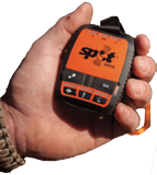
Increasingly, emergency services, including military first responder groups, recognize and have come to rely on the reliability, versatility and unparalleled reach of satellite communications networks such as Globalstar, and in particular SPOT—they are putting these tracking and communications solutions to work at the heart of their rescue operations.
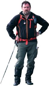
Steve Wood, Chairman of leading mapping solutions provider Mapyx, has seen first-hand how Globalstar’s SPOT system has been adopted by numerous UK emergency and rescue services.
“The rationale is simple,” Wood said. “In an emergency situation, numerous agencies need to mobilize rapidly and they must have reliable and interoperable communications systems. Failure is simply not an option when it comes to preserving life and preventing death.”
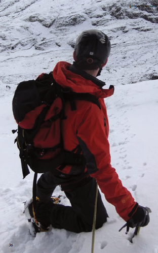
Mapyx works closely with UK Mountain Rescue England & Wales, Lowland Rescue, the UK Ministry of Defence (MoD) Military Mountain Rescue and Police Forces. Additionally, Wood has an in-depth understanding of the operational needs of fire services throughout the length and breadth of the UK. The flooding that battered the UK coastline in the early months of 2014 has really driven home the need for world-class asset tracking and communications technologies for the agencies involved in providing emergency support.
The terrestrial-based radio networks that military, government and civilian rescue organizations depend on for their communications—all proven and reliable technology—can be lacking when ubiquitous, uninterrupted communications in remote areas are needed.
“Radio communications work perfectly within the radius in which ample repeaters have been installed,” said Wood. ”However, the story is quite different in remote areas.”
In remote regions where repeater stations are fewer or have not been installed, and where mobile cellular coverage is weak, unstable or non-existent, when there is a need for reliable communications, satellite truly is the only answer.
Wood is all too familiar with the fact that publicly funded organizations are under more budgetary constraints than ever before in post-recession Britain, as well as in other countries around the world. Cutbacks in military spending are a reality in the US and beyond.
Those rescue services that rely upon charitable donations are facing even more acute funding challenges—donations are down and in some cases funding is insufficient to carry on an organization’s operations, to the point where some volunteer first responder agencies have had to cease their good works.
Wood argues, however, that in terms of the human cost of failing to reach lost people and to deliver food and medical supplies to regions cut off by flood and fire, first responders simply must have communications systems they can depend on to carry out their roles with maximum efficiency.
“Quite a lot of publicly funded rescue organizations are looking at satellite communications,” he said. “We ourselves have seen more and more selecting Globalstar solutions for asset tracking. A host of Mountain Rescue and Fire Service organizations are turning to satellite communications as that is really the only solution that can be completely reliable.”
“The adoption process can sometimes be slow: There is a lot of educating that still needs to be done,” he added. “But the progress is sure and steady. Rescue organizations that have adopted satellite-based solutions, such as Globalstar and SPOT, are vocal about how these solutions have transformed the way they work.” Indeed, many of these groups are nothing short of evangelical in their advocacy of SPOT’s tracking capabilities.(Please read the accompanying sidebar below.)
Wood is optimistic about the uptake of satellite services. “With the pricing of today’s satellite-based communications being lower than ever before, we can anticipate a much wider adoption of solutions such as these.”
Wood anticipates that more emergency responder groups will use SPOT for tracking in emergency situations in multiple geographical environments.
All Londoners vividly remember the “7/7” terrorist attacks that occurred in July 2005. Rescue efforts were hampered by the fact that all mobile networks buckled under the pressure of call traffic. During such instances, mobile network operators give priority of use to emergency services. Consumer usage is given a lower priority. Even so, the networks seized up as they were inundated by calls from people trying to determine the safety of loved ones.
This highlights a unique feature of satellites orbiting in Low Earth Orbit (LEO). The perceived wisdom is that satcom is ill-suited to urban usage as, typically, line of sight is required to maintain a connection with the satellites orbiting in geostationary orbit.
However, with a large fleet of satellites moving rapidly across the horizon in LEO, there is built-in redundancy. In fact, the Globalstar network configuration allows a customer’s handset to communicate with up to three different satellites at any given time and ultimately choose the satellite with the best signal strength. This effectively means that an emergency call or tracking signal can remain connected at all times. Furthermore, the system can potentially bear a much higher volume of traffic than radio or cellular alternatives due to the high bandwidth and capacity of satellites.
SPOT GPS Messenger Coverage
“SPOT devices are being used to track vital operational assets so that teams can get those assets to the incident faster,” explained Wood. “A paramedic can get a more accurate picture of how many minutes it will take an air ambulance to arrive, and where a cardiac defibrillator is located in order to engage in a speedy response to a casualty to increase the odds of saving a life.”
“If you know where your assets are, you can deploy them more effectively,” Wood said.
In the example of a missing person search, all rescue groups have to swiftly mobilize under the direction of local police. All rescue teams involved need to be able to communicate seamlessly on the same platform. Such interoperability is critical. Any incident commences with dissemination of key information and soon becomes a planning and control exercise. Search teams must be able to accurately know which areas must be searched, and, equally importantly, to know which areas have already been searched. Knowing the location of your assets is vital and that is where the SPOT system comes in to its own.
“The SPOT network can be accessed everywhere, even in remote areas, and first responders don’t need to worry about their communication systems being incompatible or getting clogged up with traffic.”
Mapyx adds a highly valuable layer of functionality to the solution in that it provides a full search management, control system and tracking interface that ties into local Ordnance Survey maps, aerial imagery and even building plans. This type of mapping provides highly granular information on local terrain conditions as well as helpful local information, such as landmarks and features that typically do not appear on Google Maps. The combined solution of SPOT and Mapyx solutions deliver a powerful communications and intelligence tool that UK relief and rescue organizations are rapidly considering to be invaluable.
SPOT Gen3 from Globalstar: SPOT devices have been used in more than 2,921 rescues in 69 countries around the globe.
“We are finding that, when working with our emergency response partners in the UK, satellite communications from Globalstar are very efficient and highly effective in a huge range of rescue and relief situations.”
http://international.findmespot.com/
http://www.mapyx.com/
Editor’s note
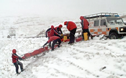
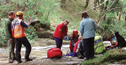
The rescue imagery is courtesy of Mountain Rescue England & Wales.
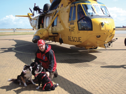
All additional imagery is courtesy of Mapyx + Globalstar.
SPOT global coverage. Image courtesy of Globalstar.
* * * * * * * * *
International Emergency Response—Help Is At Hand Wherever + Whenever Needed
The GEOS International Emergency Response Coordination Center (IERCC) was officially founded in November of 2007 as part of the GEOS Alliance, with the culmination of various 24×7 monitoring centers that individually focus on travel safety, security services and monitoring for clients.
The monitoring activities of these centers—which were disparate and separate entities—covered a number of services and technologies involved in notification, tracking and emergency alert messaging. Independently, these centers have been operating since the late 1990s. They now operate collaboratively across the globe via reciprocal agreements and have agreed upon common practices—in effect, their combined facilities now act as a global safety and rescue network.
Mark Garver, CEO of GEOS Response, shared his insights on the range of rescues that owe their success to SPOT from Globalstar.
“When we started working with SPOT in 2007, the majority of rescues were in North America, typically in remote locations. The really unique aspect of the SPOT system is the ability to pinpoint where the emergency is situated. When we receive an emergency activation coming into our center, we are able to look at the latitude and longitude of the event. When we call first response organizations, we can inform them quickly as to the location of the emergency, whether the person is moving, what direction he or she was going, and so on. We can guide the first responders rapidly to the emergency site and exactly where the victim(s) are located.
“We have grown our organization and have developed extremely good relationships with first responders, worldwide. There were other systems in existence prior to SPOT. However, what has made SPOT so successful is its GPS positioning. Previously, when an emergency was reported to us, it identified a pretty broad area.
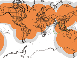
SPOT global coverage. Image courtesy of Globalstar.
“Rescuers had to engage in a formulaic search pattern—they would send out search parties and eventually they would get closer and closer to where the incident was taking place. In the end, they would hear the distress beacon and could then provide the rescue. With the advent of the SPOT device, rescuers can move directly into that all-important four-meter range. This allows those teams to more closely zero in on where an incident has occurred. SPOT ensures emergency services get to the site far more quickly as well as to a more precise location to render aid—no question, this is a great life-saving device.
“The range of contexts in which SPOT has played a critical role is huge. Just north of Houston, Hurricane Katrina destroyed communications networks. When a house caught fire, the owner activated his SPOT device and we were able to get the local fire department to the scene rapidly. We were also able to pinpoint the location of several SPOT users who issued distress calls during the 2012 tsunami in Indonesia. We swiftly co-ordinated rescue relief and liaised with the US State Department to share the location of US citizens in need of help.
“Similarly, when Haiti was devastated by an earthquake in 2010, most first response resources were immediately occupied with emergencies all over the country. Communications networks were totally non-functioning, but with the aid of SPOT, our organization was able to locate an available relief team and then dispatch them to a user in need of aid.
“During avalanche season in the US and Canadian Pacific Northwest, each year we receive a growing number of SOS calls from skiers and snowmobilers who are lost or injured. In fact, in one instance, two mountain rangers were caught in a whiteout in Colorado and became disoriented. Following a SPOT activation, we were able to quickly put them in touch with other members of their organization, who were instantly informed of where their colleagues were located. We were able to give them dynamically updated location information which they then plotted on a mapping interface, enabling them to see ridge lines and additional guiding landmarks. The rangers had dug a snow cave for themselves, thinking they would spend the night totally snowbound. However, we were able to safely guide rescuers to their location and all reached shelter before the freezing nightfall.

“One of our most interesting rescues involved a French SPOT user and his daughter who were kayaking in northern Siberia. They suddenly found themselves in waters too wild to be navigated. They activated their SPOT device and we contacted Russian Search and Rescue. The rescuers—transported with the aid of a sure-footed mule—soon located the pair in the remote region and successfully transported them to safety.
Garver added, “There is one key message I would like to share with rescue and relief agencies who are considering the procurement of communications and tracking technology: Equipping your staff with a device that pinpoints location and does not rely on terrestrial communications can really be a life-saver.
“No matter what the emergency, with a device such as SPOT, the push of a single button places you into direct communication with an organization that has close relationships with a worldwide network of agencies that rapidly assist, wherever aid is needed.
“What would I say to first responder organizations that are hamstrung by budget cuts? That’s a tough one, but I would say, try to find the money, from somewhere. One life lost is something that no one wants to experience. The cost of these solutions is minuscule when compared to the lives that otherwise could not receive aid in time during an emergency and be lost.”
http://www.geosalliance.com/geos-services/worldwide-search-and-rescue/
http://www.findmespot.com/en/index.php?cid=104