
Much in the same way that global positioning once shook the world, BlackSky is providing a new perspective on geospatial intelligence, expanding it out of the defense and intelligence domain and putting it in commercial hands.
Click on article images to enalrge
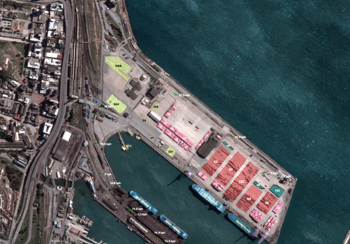
Three images were collected in rapid succession over Port Elizabeth, South Africa, on August 10, 2020, at 11:31 a.m. local time.
By analyzing these images, BlackSky is able to extract critical economic and financial indicators to offer a nearrealtime view of commercial activity in Port Elizabeth.
In particular, with the assistance of Spectra AI, BlackSky can count the number of container stacks in the container yard, identify the container
and bulk carrier ships currently berthed, count the number of vehicles awaiting export in the car terminal, track ground vehicle movements,
and even determine which cargo holds are actively being loaded. With the everincreasing revisit rates offered by the BlackSky Global
constellation and the advanced automation capabilities enabled by Spectra AI,
economic activity is revealed at a velocity previously thought impossible.
BlackSky is making good on its promise to deliver first-to-know global observations on emerging events and anomalies using deep activity monitoring and predictive analytics.
This near real-time intelligence — once the sole province of top defense and intelligence organizations — is now affordable and accessible for commercial use.

And that opens up entirely new avenues of opportunity for the use of space-based intelligence.
More than a satellite company, BlackSky is truly a global monitoring company.
By combining geospatial information with a variety of sources, sensor data and IoT feeds as well as leveraging artificial intelligence (AI) and machine learning (ML) techniques, BlackSky’s Spectra AI platform provides an unprecedented level of data depth and analysis for customers at almost instantaneous speeds.
Global Monitoring Highlights BlackSky’s Innovation Curve
BlackSky’s platform has found favor as a valuable tool for intelligence, surveillance and reconnaissance (ISR) related missions and for tracking major global events. This has led to several significant contracts this year.
As part of a multi-year contract with the Defense Innovation Unit (DIU), BlackSky will be providing the U.S. Army Tactical GEOINT (TacGEO) prototype program (see below) with its high-revisit, low-latency constellation architecture.
The Department of Defense (DoD ) is leveraging BlackSky’s low-cost, high-revisit, small imaging satellites to develop critical concept of operations (CONOPS) including tactics, techniques, and procedures, and to inform future operational systems.
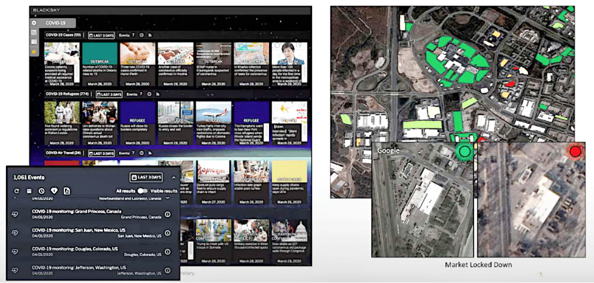
BlackSky was also awarded a contract leveraging its AI platform to monitor the efficacy of global COVID-19 mitigation efforts. Specifically, BlackSky’s Spectra AI has been enlisted to monitor overseas U.S. military bases and help secure critical supply chain nodes. The company’s global monitoring capabilities will track the outbreak and spread of COVID-19 to ensure the protection of deployed personnel.
Screenshots from BlackSky’s Spectra AI platform are courtesy of the company.
Tasking Satellites With Your iPhone
BlackSky has overcome enormous barriers, in place for decades, to increase the company’s capabilities for rapidly iterating, evolving and innovating smallsats in Low Earth Orbit (LEO). Today, with Spectra AI, customers can easily task a satellite from any internet-connected device to affordably obtain images and timely insights.
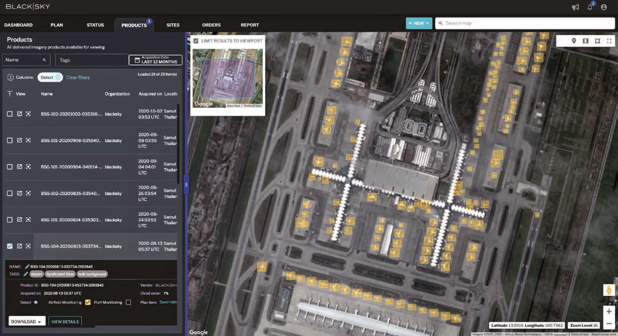
This image shows the impact of COVID19 on air travel on Bangkok's Suvarnabhumi Airport. Many parked aircraft are visible in this image as well as the new satellite terminal, whose opening has been delayed by the pandemic.
The next phase of growth will enable the company to serve more commercial clients, especially as we grow our constellation. We have six satellites on orbit now and will add 10 more by end of the 2021.
BlackSky is also seeing interest from a number of companies such as risk management and investment research firms, strategic intelligence and consulting companies, security service businesses, non-profit think tanks, geospatial analytics companies, internationally sustainable development agencies, public transportation organizations and airlines.
Like that historic GPS moment in global technology, BlackSky’s Spectra AI is creating new expectations today and has the potential to change the future. https://www.blacksky.com

Author Brian O’Toole is the Chief Executive Officer of BlackSky.
BlackSky has initiated the next phase of expansion of its high-revisit commercial satellite constellation with the unveiling of its next generation, Gen-3, satellite architecture.
In addition, the company also announced it has conducted the preliminary design review of its Gen-3 satellite design for the U.S. Army Tactical GEOINT (TacGEO) prototype program as part of a multi-year contract with the Defense Innovation Unit (DIU).
 A single ship (in yellow) approaches Grytviken in South Georgia and the South Sandwich Islands at 5:25 p.m. local time on August 10, 2020, as captured by BlackSky8. An image at this time of the day is achievable due to the specific inclined orbit of the BlackSky satellites. All ships entering Grytviken are
required to pass a thorough COVID19 screening process before
entry is permitted.
The commercial constellation expansion features Gen-3 satellites capable of producing images with 50 cm resolution and the hosting of multiple sensors that include short-wave infrared (SWIR).
The improved resolution and enhanced spectral diversity of the Gen-3 satellites will extend BlackSky’s ability to provide real-time insights to the firm’s customers via a broad set of conditions, including nighttime, low light and challenging weather.
The TacGEO program is designed to support the DoD’s needs for responsive, space-based intelligence, surveillance, and reconnaissance (ISR) for tactical applications.
The TacGEO program is a science and technology program to demonstrate the tactical utility of a single satellite of Gen-3’s capabilities.
The TacGEO project leverages BlackSky’s high-revisit, low-latency constellation architecture to address a growing need for responsive intelligence, surveillance and reconnaissance for the tactical ISR missions.
BlackSky’s Gen-3 satellites will enable rapid distribution of highly responsive insights to warfighters to support concurrent war games, exercises, and combat training center events and help measure technology readiness.

BlackSky smallsats constellation on orbit.
Image is courtesy of the company.
BlackSky accelerates the DoD’s ability to leverage low-cost, high-performance, small imaging satellites to develop critical concept of operations (CONOPS) including tactics, techniques and procedures, and to inform future operational systems.
The contract was awarded to BlackSky in January 2020 after a competitive bid process. The TacGEO satellite program is now well into the design and development phase and is on track to launch and demonstrate operational capabilities in 2022.
“BlackSky is committed to ensuring the success of our customers’ missions. Our strategy of combining rapid evolution and deployment of space-based remote sensing capabilities with an industry leading AI-driven analytics and delivery platform will ensure that our customers are always the first to know,” said Brian O’Toole, CEO of BlackSky. “We are very proud to have reached this performance milestone. It demonstrates our ability to leverage a next generation space and analytics architecture to deliver new insights at a pace and economics unprecedented in the industry.”
The Gen-3 design is an evolution of the Gen-2 system that is currently in production with BlackSky’s satellite partner, LeoStella. BlackSky’s rapid innovation approach and vertically integrated architecture enables it to produce new generations of satellites, while continuing full-scale production and operations of its current satellites. This agile development and production strategy will enable BlackSky to complete design and manufacturing of its Gen-3 satellites in less than 24 months.
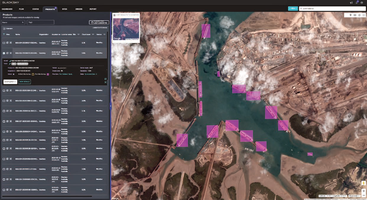 BlackSky routinely monitors Port Hedland, the highest tonnage port in Australia, for changes in activity expected to influence regional iron ore prices.
 This image shows a BlackSky satellite manufactured by LeoStella. Image is courtesy of LeoStella