
On April 3rd, 2014, a satellite carrying a U.S. Naval Research Laboratory (NRL) space weather instrument launched from the U.S.A.F.’s Vandenberg Air Force Base. Called the Special Sensor Ultraviolet Limb Imager (SSULI), “SSULI makes accurate measurements of the upper atmosphere and ionosphere that are ultimately useful to the warfighter,” said Dr. Scott Budzien, the NRL Program Manager.
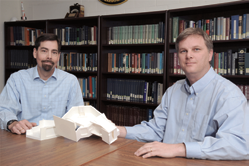
Dr. Scott Budzien and Andrew Nicholas hold a model of NRL’s SSULI, an instrument to measure ionospheric density from an orbiting satellite. “What’s really important is that [SSULI] helps provide a very good specification of the state of the atmosphere—a nowcast,” said Budzien. Photo is courtesy of the U.S. Naval Research Laboratory/Jamie Hartman
The SSULI instrument was incorporated into the Defense Meteorological Satellite Program (DMSP) satellite, launched aboard an Atlas V launch vehicle. Since the mid-1960’s, the DMSP’s Low Earth Orbit (LEO) satellites have provided the military and civilian communities with important and reliable environmental information. Each DMSP satellite has a 101-minute orbit, circling between the North and South poles and providing global coverage twice a day. The Air Force, in partnership with the National Oceanic and Atmospheric Administration (NOAA), works to continually improve the developing science of weather forecasting. DMSP satellites produce global coverage to provide the military with timely, accurate and continuous weather information.
“Down in the lower atmosphere, the characteristics of weather that are important are temperature, precipitation, wind, and so on,” he said. “But in the ionosphere, the aspects that are important for our systems are electron density, the morphology and gradients of electron density, and the height where the ionosphere lies.”
SSULI measures the density of the ionosphere (as ions or electrons per cubic centimeter). Said Andrew Nicholas, the Principal Investigator, “We are measuring naturally occurring airglow emissions from the upper atmosphere.” The density profiles go into the Department of Defense’s weather system, which the U.S. Air Force has run since the 1940s to collect observations about terrestrial and space weather.
“SSULI helps provide a very good specification of the state of the atmosphere—a nowcast,” said Budzien. With a more accurate nowcast, forecasting models better predict space weather into the future. Space weather is important for military operations, because how signals are transmitted or reflected influences the reliability of radar and of communication and navigation systems.
The April 3rd DMSP mission, Flight-19 (F19), is the fourth to carry a SSULI from NRL. “They fly in a sun-synchronous orbit, which means they are always at the same local time,” said Budzien. “The one we are launching in April is going into a terminator orbit, right at the day-night boundary.”
NRL built five SSULIs in the early 1990s; the last launch is currently planned for 2016. But, said Budzien, “Based on the lessons learned from SSULI, we’ve developed the design for a smaller, more sensitive instrument.” Still just a concept, Budzien hopes to identify a sponsor who will help “to continue to provide improved products for the warfighter.”
Atmospheric Scanning
Nicholas explains how SSULI scans the atmosphere from about 50-750 km using a moving mirror. “SSULI performs one vertical scan of the atmosphere every 90 seconds as it flies above the earth. During that 90 seconds, each second we grab the data for one altitude.” SSULI then resets its mirror to 50 km and starts again.
At each data point, SSULI observes how many atoms are becoming charged ions by losing electrons; interpreting the ion signal at each altitude gives the scientists an electron density profile of the ionosphere.
Said Nicholas, “Sunlight and solar ultraviolet radiation illuminate atoms in the atmosphere. Each photon from the sun will be of a certain wavelength, and that wavelength will have a certain amount of energy with it.” Photons from the sun may strip an electron from an atom, giving it a positive charge until the electron returns or recombines, generating photons of various wavelengths; or excite an atom to a higher energy state, until it loses energy by emitting a photon of a characteristic wavelength.
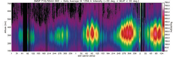
Said Andrew Nicholas, Principal Investigator, “What we’re looking at is naturally occurring air glow emissions from the upper atmosphere.” Shown is the daily averaged electron density over two years; as a function of altitude and day of the year in the post-sunset, equatorial ionosphere. F18 SSULI measured the nightside oxygen 135.6 nm radiative recombination emission intensity, capturing the ionosphere’s variations daily and over the long-term as associated with seasons and solar cycles. (Please see the graphic on the following page.)
The algorithms to interpret this complicated interaction are different for a dayside orbit versus nightside, largely due to solar forcing. “You could be observing airglow at the same wavelength,” said Nicholas, “but different physics drives what’s happening in the atmosphere during the day and night.” This makes the terminator orbit, where the next SSULI will be observing, “the toughest one, because the twilight conditions have a mix of daytime and nighttime physics.”
Said Budzien, “We developed all the operational software that’s used for analyzing the [SSULI] data products, and we provided that to the Air Force.”
Aside from space weather, said Nicholas, “[SSULI] allows researchers to better understand the effects of atmospheric drag and how that affects satellite orbits.” The density of the atmosphere, which changes with solar conditions, creates drag on orbiting satellites. This can eventually cause satellites to slow and even to fall back into the earth’s atmosphere.
Said Andrew Nicholas, Principal Investigator, “What we’re looking at is naturally occurring air glow emissions from the upper atmosphere.” Shown is the daily averaged electron density over two years; as a function of altitude and day of the year in the post-sunset, equatorial ionosphere. F18 SSULI measured the nightside oxygen 135.6 nm radiative recombination emission intensity, capturing the ionosphere’s variations daily and over the long-term as associated with seasons and solar cycles. Photo is courtesy of the U.S. Naval Research Laboratory.
“A practical consideration for atmospheric drag,” adds Budzien, “is that you need to be able to predict when a satellite is coming over the horizon in order to be able to communicate with it. If there’s more [drag] than you expect, the satellite doesn’t show up at the right time.”
Rigorous Testing + Calibration For SSULI
NRL launched the first SSULI in 2003. “Because the program has spanned so many years,” said Budzien, “we’ve performed some continuous product improvement. The guts of the instrument are still the same optical design, but we’ve upgraded detectors and we continue to make minor modifications, as needed.”
Over the past several months, NRL has been prepping SSULI for launch and calibrating its sensitivity performance. “We calibrate the sensor on the ground against ultraviolet reference detectors, using laboratory light sources,” said Nicholas.
SSULI launched aboard a rocket 170 feet long and 12 feet wide, most of which is taken up by fuel. “You basically build these things to survive the launch,” said Nicholas. “The launch is a very violent, fast event.” NRL has vibration tables and an acoustics chamber programmed to simulate the specific rocket for the April launch. “You put your instrument on the table, and it shakes it like crazy. That minute seems to last forever.”
The last thing the team of NRL engineers and scientists will do, said Nicholas, is “crawl inside the top of the rocket 24 hours before launch to do the last minute servicing of the instrument.” At 40 pounds, SSULI is mid-sized compared to the other instruments on the DMSP satellite.
Nicholas said of the launch, “It’s an awesome thing to watch.” But the job of a successful launch and ejecting the satellite to the right orbit is out of their control; so it’s “first light” when they hold their breath.
Said Budzien, “Making the instrument work, and work well, that’s in our control. So that’s the moment of truth, when you open up the instrument door, turn it on to collect data for the first time, and say, ‘Okay, excellent job.’ “
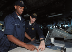
Sailors navigate aboard USS George WashingtonSailors plot course aboard USS George Washington (CVN 73). NRL tools for ionosphere forecasting, such as SSULI, help predict satellite reliability for navigations and communications during naval missions. Photo is courtesy of the U.S. Navy.
NRL continues to launch SSULIs because the sensor takes useful scientific measurements for only three to five years. “The data process relies on something called a microchannel plate,” said Budzien, which is made of glass. “Over time, as they’re used, they eventually degrade and become less sensitive, eventually to a point where the signal isn’t scientifically useful anymore.”
A Follow-On To SSULI
In addition to being smaller and using less power, NRL’s design for the next sensor doesn’t scan in the old way. Said Budzien, “We’ve developed a way, in the follow-on instrument, to stare at the atmosphere a little bit more like a camera, where we can see the whole altitude range at once. That gives us a higher effective sensitivity.”
“If you’ve got a really sensitive camera,” adds Nicholas, “you can do a better job with fewer photons.” Better sensitivity will enable scientists to still analyze the ionosphere, even when the electron density is very low, which can happen as the sun’s activity changes through its 11-year cycle.
Compared to terrestrial weather, Budzien said ionosphere forecasting is “in its infancy. Space is big, and we don’t have all that many sensors up there. It’s a sparse data set, which makes modeling a real challenge.” Both are excited to contribute to a field that, in the last 20 years, has attracted a lot more interest.
“Now that more and more missions are flown,” said Nicholas, “more and more data are coming together. From a research perspective, that’s really what’s needed.” NRL works with the U.S. Air Force and Utah State University to improve ionosphere forecasting beyond the current capability of about 24 hours.
NRL archives all SSULI data, which enables scientists to go back and analyze how significant solar activity, like coronal mass ejections, change the ionosphere. “Where the science comes in,” said Budzien, “is that we can make an accurate measurement of the response of the atmosphere. Comparing the response to the input gives us information about the physics connecting the two.” Understanding the feedback mechanisms of space weather will enable more accurate, more long-term forecasts.
NRL has a long history of launching satellites and—as one of the only places where a satellite can be designed, built, and tested in-house—is uniquely poised to continue supporting the military. “This is a world-class facility,” said Nicholas.

About the author
Kyra Wiens is a Public Affairs Specialist for the U.S. Naval Research Laboratory (NRL). She’s written about the lab’s achievements in alternative energy, biochemistry, space science, and more; sharing with social media and reporters. She’s also an All American triathlete.
About the U.S. Naval Research Laboratory
The U.S. Naval Research Laboratory is the Navy’s full-spectrum corporate laboratory, conducting a broadly based multidisciplinary program of scientific research and advanced technological development. The Laboratory, with a total complement of nearly 2,800 personnel, is located in Southwest Washington, DC, with other major sites at the Stennis Space Center, Mississippi, and Monterey, California. NRL has served the Navy and the nation for over 90 years and continues to meet the complex technological challenges of today’s world.
To learn more about the U.S. Naval Research Laboratory, visit http://www.nrl.navy.mil/
