Military missions simply cannot succeed without reliable communications. This means satellite technology is essential for operations. MILSATCOM allows combat outposts to link directly with the command center, base compound, remote missions facilities, strategic operations, enable the use of Communications-on-the-Move (COTM) and facilitate the emergencies remediations.
High frequency (HF) radio is also needed on military missions. HF is constantly used in many operations—however, such is not always the case. For example, there are many locations in Afghanistan where communications absolutely demand satellite connectivity—for instance, between locations such as Herat and Kabul. Satellite enables soldiers to communicate worldwide in receiving their orders and assist commanders in making crucial decisions based on real-time information that is transferred though a satellite link. Therefore, high-speed broadband connectivity available anytime, anywhere, is an absolute must. Accurate satellite deployment and link budget calculations are required to quickly establish the comms line, to remain connected, and maximize communication availability and performance.
In military missions, soldiers face a major challenge in pointing, lining up, and commissioning a VSAT antenna. Accessing the satellite is time consuming as satellite operators require accurate pointing and cross-pol isolation. Traditionally, soldiers need to coordinate phone calls to the NOC (Network Operations Center) and perform the lineup, which can require more than 30 minutes.
This process is tedious and technically complex. Calls from remote areas generally require expensive satellite phones due to the lack of cellphone connectivity. On these calls, the satellite operator specialists manually guide soldiers in lining up the antenna, all based on measurements acquired at the NOC. If soldiers do not call the NOC, they are quite likely to create cross-pol and cause adjacent satellite interferences. Poor performance is the result and the antenna lineup will need to be repeated until accurate commissioning is obtained, which requires extra time, cost and even mission failure with subsequents cost being a failed mission and loss of life.
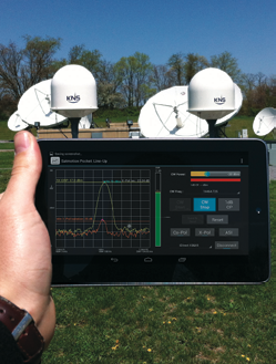
SatMotion Pocket VSAT Line Up application in use. Photo courtesy of INTEGRASYS.
Today, a new technology facilitates VSAT line ups in the field, minimizing the time and resources required to establish the commission. Soldiers can autonomously commission remotes using a lightweight device, such as a smartphone loaded with an intuitive app. No technical skills are required. The process is highly secure and does not require a phone call to the NOC or any cellular connection. This solution is called Satmotion Pocket. iDirect has added Satmotion Pocket to its product portfolio as the iDirect Remote Commissioning Solution in order to automate and speed up remote commissioning of iDirect networks.
Satmotion Pocket is based on a carrier monitoring system that is installed at the hub, sharing the information with multiple, simultaneous soldiers in the field. This system allows soldiers to quickly point, peak and pol by displaying accurate measurements, all accurately displayed in the soldiers’ hands. This remote commissioning technology increases availability and bandwidth efficiency as the antenna is pointed accurately. Additionally, Satmotion Pocket automatically performs the 1dB compression test to calculate the BUC saturation point with just a click of a button.
The Satmotion Pocket Line Up method employs four steps:
• Antenna Pointing: In this step, the app displays on the soldier’s smartphone maps and ground references
that indicate where to point the antenna. After the rough pointing is completed, the app receives the
forward signal from the satellite and displays an SNR value.
• Peak and Pol: The soldier can transmit a CW carrier and optimally adjust the power. By moving the orthomode, the cross-pol interference over 35dB is
minimized, in many cases.
• Automatic 1dB Compression Point: A soldier presses a button in the app and Satmotion Pocket displays the BUC saturation point.
• Report: After the installation is finished, a complete report is generated for post-install analysis at the Hub.
Satmotion Pocket saves a significant amount of time in antenna lineup by making the process far simpler to complete. Additionally, the device reduces interferences and maximizes communication performances.
Network design plays a key role in satellite availability where link budget calculation tools are required. Integrasys has a satellite high fidelity link budget calculation tool called “GeoBeam” for satellite networks that allows them to achieve maximum communication availability for all missions.
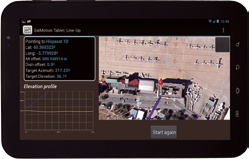
SatMotion Pocket in use on a Samsung table. Image courtesy of INTEGRASYS.
GeoBeam analyzes the potential satellite coverage, symbol rate, and antenna size requirements, taking into account weather conditions, miss pointing and interference factors in order to maximize availability. This link budget calculation software generates an extremely accurate and comprehensive PDF report that provides Return and Forward Link Budget for a satellite network. The report includes multiple diagrams on ground maps for any given mission within the selected area. Additionally, SatMotion Pocket could be used to simulate communications on UAV missions using the AeroTackCOM plugin.
Integrasys’ goal is to assist warfighters and use satellite communications more effectively by increasing communications availability and through the establishment of satellite communications in an accurate and rapid fashion. To download the SatMotion Pocket datasheet, access
http://www.integrasys-sa.com/datasheets/satmotp.pdf
About the author
Alvaro Sanchez is the Sales and Marketing Manager at Integrasys, responsible for the worldwide sales and marketing department, and head of the U.S. office. Alvaro is also in charge of the Satellite Product line.