Department of Defense (DoD)—Speaking Of Spectrum Sharing...

The Department of Defense has announced its electromagnetic spectrum strategy for sharing with the commercial wireless industry.
The electromagnetic spectrum is a range of frequencies of electromagnetic radiation. Electromagnetic radiation has many uses, including radio and satellite communications, radar, and GPS.
“Through its plan, DoD recognizes that meeting its own requirements amidst the growing commercial and consumer demand will require cooperation, compatibility and flexibility,” said Karl Nebbia, the associate administrator of the Office of Spectrum Management at the electromagnetic spectrum strategy press briefing,
“A key focus of its plan is to establish goals and objectives to develop systems that are efficient, flexible and adaptable in their use of the spectrum.”
The focus in sharing the spectrum is balancing the needs of the military and the needs of the commercial wireless industry, both of which have growing demand.

“We cannot shift in a short time frame; we just have too much equipment and too much capability that really has to be transitioned in a very thoughtful way so as not to impose a major burden on budgets and a major burden on the taxpayers,” said Teri Takai, chief information officer for the Department of Defense.
In the 1990s, 12,000 troops used an average of 90 megahertz of bandwidth. Now, 3,500 troops use over three times that amount of bandwidth on average.
“The longer term spectrum needs for government agencies and industry alike can only be met through spectrum sharing. And we are looking for a top-to-bottom commitment from all stakeholders to make it happen,” said Nebbia.
There are three main goals embedded in the strategy: continue improving DoD spectrum-dependent technology, increase the agility of spectrum operations, and improving participation in policy,” said Takai.
“By becoming more efficient, flexible and adaptable, our systems will be better prepared to meet the demands of modern warfighting,” said Takai. “This creates opportunities to utilize spectrum that is less congested, adopt commercial services and technologies where suitable, and implement spectrum-sharing technologies where feasible.
“So with all of that, again, our objective is to really work collaboratively, but always with a mind towards our mission, which is really to protect all of our citizens and all of our partners and make sure that all of our men and women in uniform have the capability that they need and are also protected from harm’s way,” she said.
Story by Cpl. Sarah Cherry, Marine Corps Air Station Beaufort
* * * * * * * * *
U.S.A.F. Space & Missile Systems Center (SMC)—A General Change of Leadership
There’s to be a new commander, if all proceeds according to play, at the helm of the U.S.A.F.’s Space and Missile Systems Center (SMC), located at Los Angeles Air Force Base, California.

Lt. Gen. Pawlikowski is heading for D.C.
The current commander, Lieutenant General Ellen Pawlikowski, will be moving in as the assistant secretary of the Air Force for acquisition at the Pentagon, should her nomination be approved by the Senate.

Being recommended to head up SMC is Maj. Gen. Samuel Greaves
Having led SMC since mid-2011, she has been described as a sterling leader by none other than the commander of Air Force Space Command, General William Shelton.
Lt. Gen. Pawlikowski also served as the deputy director of the National Reconnaissance Officer (NRO) from 2008 through 2010.
She will be nominated to gain rank to that of Major General.
Being recommended to take her place at SMC is the current deputy director of the Missile Defense Agency (MDA), Major General Samuel Greaves, who will be additionally nominated for promotion to the rank of Lieutenant General.
Following protocol, both of these candidates must be confirmed by the Senate.
* * * * * * * * *
U.S.A.F. 21st Space Ops—25 Years Of Tracking + Space Support @ Kaena Point
On February 26th Kaena Point Satellite Tracking Station celebrated 55 years of space operations.
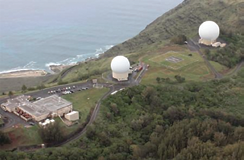
The tracking station is located near Kaena Point above Keawaula Bay on the island of Oahu, Hawaii. Kaena Point is part of the Air Force Satellite Control Network, which consists of seven remote tracking stations located around the world.
“Kaena Point is a beautiful place to work, and has a long standing history of loyalty and service to the United States,” said Charlene Kaawaloa, a longtime administrator at
Kaena Point.
The site operates two AFSCN antennas used to support more than 150 Department of Defense, national and allied satellites with missions, such as communications, reconnaissance, navigation, weather and early warning.
The station is managed by the 21st Space Operations Squadron Detachment 3. Detachment 3 is a geographically separated unit of the 50th Space Wing located at Schriever Air Force Base, Colorado. Contractors provide around-the-clock manning for command and control of on-orbit satellites. Additionally, there are 15 Air Force civilians providing base operations and support.
“Being part of Detachment 3 has been an eye opening experience,” said Tech. Sgt. Kyle Fenimore, Detachment 3 NCOIC. “Space has always been a hobby of mine, but I never thought I would get the chance to be directly involved in the command and control of satellites.”
Construction at Kaena Point began in 1958 and operations supporting the nation’s first satellite reconnaissance program, Discoverer, began in February 1959. The Discoverer program, which was declassified in 1995 and is now known as Corona, was developed to collect photographs of areas around the world including the Soviet Union and Cuba. Photographs could be taken from space without putting pilots in harm’s way and violating the airspace of other nations.

Film canisters ejected from the satellite, deployed a parachute and were recovered mid-air by aircraft from Hickam Air Force Base, Hawaii. Some canisters were also recovered at sea by ships from Naval Station Pearl Harbor.
Richard Harris, Hawaii Tracking Station chief of operations, said, “As a contractor at Kaena point, I’m directly involved in keeping satellites fully operational so they can perform their mission for our military, our nation and our allied partners.”
In 1966, Kaena Point supported 3,997 satellite contacts. The team consisted of 49 active-duty Air Force personnel and 182 contractors. At that time, schedules and mission orders were received via teletype and phone lines using under-sea cables linked the remote tracking station with the operations center in Sunnyvale, California.
Today, data transfers are much faster, and, with technological advances and communication equipment upgrades, the station can do more with fewer personnel.
Marlon Martell, an operations and maintenance technician for the past 25 years, said, “We can now communicate with multiple operations centers at greatly increased speeds and receive near real-time changes to the mission schedule.”
Today, the unit’s mission is more robust and critical than ever. In 2013, Kaena Point supported 22,255 satellite contacts, which is a huge increase from the 1960s. Kaena Point supports approximately 60 satellite contacts per day.
The site retrieves data from satellites and relays commands, such as on-orbit maneuvering, programming of the satellites’ on-board computers and maintaining the health of the satellite.
Kaena Point has been providing critical space support to enhance military and humanitarian relief operations for 55 years. Many residents of Oahu have been part of the Kaena Point Satellite Tracking Station family during its long history and have played a critical role in our nation’s security.
To everyone, we say “Aloha and Mahalo.” We look forward to another 55 years of service to the United States of America.
Story by Major George Sanderlin, 21st Space Operations Squadron, Detachment 3
* * * * * * * * *
Lockheed Martin—Designed To Investigate The Weather In Space
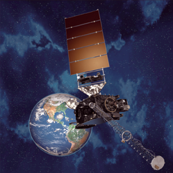
Lockheed Martin delivered a new solar analysis payload that will help scientists measure and forecast space weather, which can damage satellites, electrical grids and communications systems on Earth.
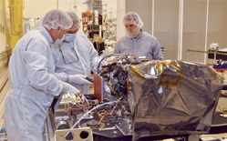
Lockheed Martin engineers in Denver install the Solar Ultraviolet Imager (SUVI) on the GOES-R Sun Pointing Platform. SUVI was built at the Lockheed Martin Advanced Technology Center in Palo Alto, California. Photo is courtesy of Lockheed Martin.
The Solar Ultraviolet Imager (SUVI) instrument was integrated with the first flight vehicle of the National Oceanic and Atmospheric Administration’s (NOAA) next-generation Geostationary Operational Environmental Satellite, known as GOES-R.
The GOES-R Series are designed and built by Lockheed Martin in Denver, Colorado.
“It is enormously satisfying to see the first GOES-R satellite and its instruments coming together, and it is great to see SUVI in flight configuration on the satellite’s Sun-Pointing Platform,” said Jeff Vanden Beukel, Lockheed Martin SUVI program director at the Advanced Technology Center in Palo Alto, California, where the instrument was built.
“We look forward to continuing our collaboration with NASA and NOAA to produce state-of-the-art scientific instruments that increase safety and improve quality of life.”
SUVI will provide the required solar observational capabilities that enable NOAA’s Space Weather Prediction Center in Boulder, Colorado, to monitor solar activity and to issue accurate, real-time alerts when space weather could affect the performance and reliability of technological systems in space or on the ground through the enhanced detection of coronal holes, solar flares and coronal mass ejections, as well as improved geomagnetic storm and power blackout forecasts.
pace weather can disrupt satellite operations, communications, navigation, and the distribution of electricity through power grids.
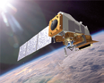
Artistic rendition of a GOES-R satellite. Image is courtesy of Lockheed Martin.
Timely forecasts of severe space weather events would help satellite operators and electrical grid technicians mitigate potential damage to such systems.
Lockheed Martin is under contract to build the first four next-generation GOES satellites (R, S, T, and U). Four of the six instruments for the GOES-R satellite have been delivered to the Denver facility and are being integrated with the spacecraft.
Once the instrument complement is completely integrated, a full suite of environmental tests will be conducted. Launch of the GOES-R satellite is scheduled for the first quarter of 2016.
Operational since 1975, the GOES program is operated by NOAA’s National Environmental Satellite, Data, and Information Service and is a critical part of the U.S. satellite constellation for environmental observations.
The GOES satellites are a key element in NOAA’s National Weather Service operations, providing a continuous stream of environmental information (weather imagery and sounding data) used to support weather forecasting, severe-storm tracking and meteorological research.
Along with weather forecasting, the GOES program also provides data to support space weather forecasting, public safety and scientific research to better understand land, atmosphere, ocean and climate interactions.
NOAA manages the GOES-R Program through an integrated NOAA-NASA office, staffed with personnel from both agencies and located at NASA’s Goddard Space Flight Center in Greenbelt, Maryland.
* * * * * * * * *
iDirect Government Technologies (iGT)— Management + Ops For SatNets Is The Focus
iGT announced the availability of its new Remote Access Training that brings an accelerated version of its popular classroom-based training and support onsite to customers via a secure remote access connection.

The accelerated courses focus on the operations and management of iGT satellite networks.
An iGT certified trainer teaches both the classroom and “hands-on” portion of the course to a class size limited to four students.
Remote access courses allow the students to visually see the hub configuration and monitor the status during the modified “hands-on” portion of the class.
Classes include:
IOM - iDirect Operation and Maintenance (IOM)
This entry-level course provides the student with the basic skills necessary to install software applications, and operate, manage and maintain a typical iGT satellite network.
Advanced IOM course
This training enables those who operate and manage iDirect satellite communication products and networks for the government and military to have a deeper understanding of the iGT system by giving the student knowledge and pointers for troubleshooting.
iQBC - iDirect Quality of Service Boot Camp
This course explains how iGT’s GQoS feature works and shows students how to configure, manage and troubleshoot the QoS feature.
The iGT training infopage is accessible at http://www.idirectgt.com/training
* * * * * * * * *
Harris Corporation, U.S. Navy, U.S. Army—End-to-End Coverage + Appliqué Application
The U.S. Navy awarded Harris Corporation an eight-year contract valued at up to $133 million to provide shipboard terminals for crews’ access to high-bandwidth voice and
data communications.
Under the agreement, Harris will provide as many as 120 terminals in addition to the 70 terminals already delivered since 2008 under the indefinite delivery/indefinite quantity Commercial Broadband Satellite Program (CBSP) Unit Level Variant (ULV) contract. The new award brings the total potential value of CBSP ULV and Force Level Variant contract awards to Harris to more than $250 million through 2022.
The program provides worldwide, commercial, end-to-end telecommunications services to the Navy.
The 1.3-meter Harris terminals offer X-band operation over existing military satellites, and the option of military/commercial Ka-band operation for future deployed satellite systems. They support essential mission requirements and provide high-speed Internet access and video communications on small combatant and support ships. Harris terminals are also used onboard Navy amphibious assault ships.
“These Harris terminals provide the Navy with access to the high-bandwidth services essential to mission-critical communications and to morale,” said Ed Zoiss, vice president and general manager, Defense Programs, Harris Government Communications Systems. “Harris is delivering the next generation of military and commercial satellite capabilities to the Navy fleet.”
Additionally, Harris has been awarded two indefinite delivery, indefinite quantity (IDIQ) contracts to supply the U.S. Army with Harris Soldier Radio Waveform (SRW) vehicular appliqué systems.
Harris was one of four companies that were selected to compete for orders on the contracts, which have a potential total value of
$988 million.
The Harris SRW appliqué systems will be part of the Army tactical network modernization program. The Harris SRW appliqué systems consist of a Falcon III® wideband radio and small form factor wideband power amplifier.
The systems provide seamless connections between soldiers, their command centers and higher headquarters. They deliver vehicular-based voice, video and data communications for enhanced situational awareness and command and control.
Harris previously announced initial orders from the U.S. Army for the appliqué system in 2012.
“The network remains one of the Army’s highest priorities,” said George Helm, president, Department of Defense business, Harris RF Communications. “Our SRW appliqués deliver cost effective SRW communications in vehicular applications, connecting the soldier at the tactical edge to the network. The appliqués also address space challenges in Army vehicles that are unable to accommodate larger, manpack-based solutions.”
In addition to SRW, the Harris appliqués also operate the SINCGARS and VHF/UHF line-of-sight waveforms, expanding interoperability with existing DoD radios and providing the Army with greater utility in combat.
For more information, please visit the Harris infosite at http://www.harris.com/
* * * * * * * * *
NOAA—CERES Set For Shipment
An artistic rendition of the JPSS-1, NOAA’s next polar orbiting environmental satellite. Image credit, Ball Aerospace & Technologies Corp.
The first of five instruments that will fly on JPSS-1, NOAA’s next polar orbiting environmental satellite, successfully completed pre-shipment review last week—the Clouds and the Earth’s Radiant Energy System (CERES) will be on board the JPSS-1 satellite mission, which is scheduled to launch in early 2017.
CERES measures reflected sunlight and thermal radiation emitted by the Earth and builds on the highly successful legacy instruments flown on NOAA’s previous Polar-orbiting Operational Environmental Satellites (POES) and NASA’s Earth Observing System (EOS) missions.
Mary Kicza, assistant administrator for NOAA’s Satellite and Information Service. “We’re on track to have JPSS-1 ready to launch in 2017, adding to a robust satellite fleet that provides vital environmental intelligence for the nation and the world.”
Long-term satellite data from CERES will help scientists and researchers understand the links between the Earth’s energy balance, both incoming and outgoing, and parts of the atmosphere that affect it.
Data from CERES will also improve observations of seasonal climate forecasts, including large-scale events like El Niño and La Niña.
The CERES instrument is built by Northrop Grumman Aerospace Systems in Redondo Beach, California., and will be shipped to Ball Aerospace & Technologies Corp. in Boulder, Colorado, to be installed onto the JPSS-1 spacecraft.
* * * * * * * * *
Airbus Defence & Space—Peruvian EO Product Planned + KazEASat-1 Almost Ready
Airbus Defence and Space has been selected as the sole, prime contractor to develop, construct and launch the first Earth Observation (EO) optical satellite system for Peru, with the support of the French government.
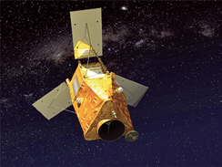
Artistic rendition of Airbus Defence & Space’ Astrobus satellite platform. Image courtesy of Airbus D&S.
The system includes a latest-generation optical satellite with its very high-resolution instrument (from the Naomi family, combining the company’s best expertise in optical instrumentation), and a ground control segment, image reception and processing center.
The project also includes a complete training program for Peruvian engineers and technicians (including satellite operations for developing tailored imaging applications).
Ahead of entry into service of the Peruvian satellite, Airbus Defence and Space will download data and images from its fleet of optical and radar satellites direct into Peru.
“With this first satellite system, Peru will acquire space capability at a very high level, and we are delighted to have been selected for our technology and expertise, particularly in the field of silicon carbide,” said François Auque, Head of Space Systems, at the signing ceremony. “In winning this contract, Airbus Defence and Space reinforces its position as the world’s number one exporter of Earth observation satellites of all types and resolution levels.”
This program will be based on the Astrobus platform, which is designed for missions as varied as imaging (Pleiades, SPOT 6&7, Ingenio, KazEOSat-1), the environment (Sentinel-2), and meteorology (Sentinel-5p). This system also benefits from the expertise developed by Airbus Defence and Space in the field of silicone carbide (SiC) space structures and instruments.
Together with its partner Boostec, the company has created, through a series of achievements in space (Herschel, Gaia, KazEOSat-1, etc.), a new, successful, economic sector.
The SiC produced in the Midi-Pyrénées region is exported around the world.
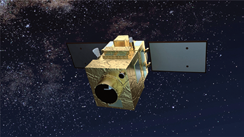
Artistic rendition of the KazEOSat-1 satellite. Image courtesy of Airbus Defence & Space.
Additionally, Airbus Defence & Space is preparing for the launch of KazEOSat-1 (formerly known as DZZ-HR), which is due to lift off on April 28, 2014, into low Sun-synchronous orbit (about 700km from Earth) on-board a Vega launcher from the European spaceport in Kourou (French Guiana).
KazEOSat-1, built on the Astrobus platform, is the Republic of Kazakhstan’s first Earth Observation satellite.
It was built entirely by Airbus Defence and Space and is a very high-resolution (1 meter) satellite weighing 900kg that will provide the Republic of Kazakhstan with a complete range of civil applications, including monitoring of natural and agricultural resources, the provision of mapping data, security applications, and support for rescue operations in the event of natural disasters.
KazEOSat-1 is the high-resolution element of a space observation system that will comprise two satellites and their ground segment. The medium-resolution satellite, KazEOSat-2, is built by SSTL, a British subsidiary of Airbus Defence and Space.
These two satellites form part of “Kazakhstan’s Space Plan”, which also includes the construction in Astana, the capital of the Republic of Kazakhstan, of a satellite integration & test center, for which key equipment is being supplied by Airbus Defence and Space.
In 2009, Airbus Defence and Space was selected by Kazakhstan as a strategic partner in this Space Plan, and has already trained 60 engineers and technicians from Kazakhstan.
Airbus Defence and Space and the joint stock company Kazakhstan Garysh Sapary, a national company under the supervision of the National Space Agency of the Republic of Kazakhstan, have formed a joint-venture named Ghalam in order to run this center.
For further information regarding Airbus Defence and Space, please visit http://airbusdefenceandspace.com/