Maritime domain awareness refers to the understanding of anything associated with a nation’s maritime domain that could impact the security, safety, economy, or environment. With water covering about 70 percent of the planet, maritime domain awareness is one of the most important activities undertaken by national and international agencies.
As the amount of global maritime traffic increases, these organizations are under increasing pressure to address issues such as illegal fishing, piracy, tracking of foreign vessels, monitoring of foreign naval forces, bilge dumping and the trafficking of people and illegal goods by sea. These activities have huge economic costs, with the estimates of illegal and unreported fishing costing the global economy between $10 and $23.5 billion annually1, and the economic cost of Somali piracy in 2012 estimated to be between $5.7 and $6.1 billion.
Traditionally, maritime security agencies have relied on surveillance aircraft, ships following patrol patterns and coastal radar to search for suspicious vessels and activities, an approach that is typically weather dependent, expensive, and reliant on limited resources. Recently, a myriad of additional data has become available, creating a big data problem that is overwhelming for maritime security agencies. The maritime environment is incredibly vast and complex, and with the massive amount of legal maritime traffic, finding a threat is very difficult.
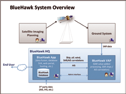
To help address these challenges, MDA has developed MDA BlueHawk, a multi-sensor, unclassified maritime domain awareness and threat detection solution that provides navies, coast guards, customs, law enforcement, and fisheries with immediate access to broad-area maritime surveillance across their Exclusive Economic Zone (EEZ) and global areas of interest. Fusing space-based radar, Automatic Identification System (AIS) data, vessel registries, and other maritime information, MDA BlueHawk delivers the information and tools to help customers detect potential threats.
MDA BlueHawk Solution Overview
MDA BlueHawk provides for the detection of non-reporting “dark” vessels, validation of reporting vessels, and identification of oil slicks, weather, and other events. MDA BlueHawk provides both open ocean and coastal coverage through the exploitation and fusion of data from multi-sensor, space-based satellite synthetic aperture radar (SAR), satellite and terrestrial AIS, vessel registry data and other contextual data.
MDA BlueHawk’s key features
• Unclassified maritime domain awareness web portal
• Detection of non-reporting “dark” vessels including observed vessel size and heading
• Identification of self-reporting vessels with verification by satellite radar
• Coastal and open water coverage (coastal and satellite sensors)
• Automatically generated alerts based on suspicious behavior
• Historical and predicted vessel tracks
• Vessel registry data (e.g., IHS Fairplay)
• Oil slick detection
• Maritime weather information
• Available as an online service, system, or direct datafeed into customer systems
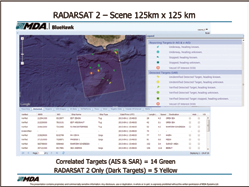
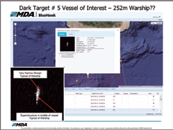
Dark (non-reporting) vessels are indicated with yellow icons in the MDA BlueHawk display (see the images below and on the next page). The white information window for this dark vessel shows the radar image, observed length, and observed heading for this vessel. The 251m length and very narrow design of this dark target are typical of a warship.
MDA BlueHawk Benefits
MDA BlueHawk offers national and international maritime agencies an efficient, cost-effective way to improve overall maritime domain awareness.
Key benefits include:
• Access a maritime picture covering vast maritime regions
• See both across your EEZ and globally, including open oceans
• See beyond your aircraft patrol boundary limits
• See non-reporting vessels, which may be the greatest threat
• See predicted routes and historical tracks of ships
• See oil slicks in your area of interest and identify the most likely polluters
• Higher resolution images provide a means to identify possible vessels of interest
Better use of existing assets with queued dispatch
• Rapid tasking and response of RADARSAT-2, allowing for approximately 30-90 minute latency from the time of satellite imaging until new vessel information is provided in the Common Operating Picture, which can be further reduced to less than 15 minutes with local ground station support.
• Sending patrol assets directly to suspicious vessels rather than patrolling empty ocean, resulting in extended range, more time “eyes on” target, and reduced fuel burn. With operating costs of maritime patrol aircraft averaging $7,500 to $11,000 per hour, the savings can be significant.
Leverage all-weather broad-area maritime surveillance
• SAR sensor allows for day or night imaging, independent of weather conditions
• RADARSAT-2 provides the broadest area coverage of any commercial SAR sensor
• The large number of imaging modes on RADARSAT-2 provides the flexibility to satisfy a wide variety of mission requirements
• MDA BlueHawk can incorporate data from other sensors (TerraSAR-X, COSMO-SkyMed, Optical) to improve coverage and revisit based on customer requirements
• Identify potential threats close or far from your shores
• Use geo-fencing to send alerts when high-risk vessels are heading towards national areas of interest
• Assess threats through intent analysis
Share information with other team members, agencies, or governments
• Unclassified data sources enable teams from multiple jurisdictions to share information and collaborate
• Web browser-based service can be deployed immediately, with no IT investment or maintenance
MDA BlueHawk Delivery Options
Delivered as an on-line hosted solution, a customer-managed implementation or a data feed into an existing end-user system, MDA BlueHawk offers an implementation model that works with any customer’s environment.
• MDA BlueHawk Online—Hosted, online web portal service
• MDA BlueHawk HQ—Customer-managed system deployment
• MDA BlueHawk DataFeed—Streaming data into existing customer systems
MDA BlueHawk In Action
MDA BlueHawk is fully operational and is in use by a number of key customers. As an example, through MDA BlueHawk Online, MDA is supporting a national Navy with their maritime domain awareness activities. In one case, the Area of Interest for the program was initially confined to an area of 1 million km2 over the Pacific Ocean, and then was expanded to cover the country’s entire EEZ. The customer is exploring a second phase of the program, and is looking to develop a business case to acquire a maritime-optimized RADARSAT-2 ground station to improve the timeliness of their response.
Notes
1Agnew DJ, Pearce J, Pramod G, Peatman T, Watson R, et al. (2009) Estimating the Worldwide Extent of Illegal Fishing. PLoS ONE 4(2): e4570. doi:10.1371/journal.pone.0004570
2Bellish, Jonathan. The Economic Cost of Somali Piracy 2012. http://oceansbeyondpiracy.org/sites/default/files/attachments/View%20Full%20Report_1.pdf

About the author
Wayne Hoyle is the Director of Business Development at MDA Geospatial Services and works with global customers in the Defense and Security sector. Much of his 30 years experience have been focused on the development and delivery of advanced systems for Maritime Situational Awareness and advanced Navigation solutions. He has worked directly with all of the 5-Eyes Navies and with many other allies. Most recently, Mr. Hoyle and his Business Development team have been delivering Maritime Domain Awareness systems which fuses data from Space based Radar and AIS sensors with users accessing the information in near real-time via a web-based portal (MDA BlueHawk™).
For additional information, please email and/or visit Bluehawk@mdacorporation.com
http://is.mdacorporation.com/mdais_canada/Offerings/Offerings_MDABlueHawk.aspx