DARPA—Five NexGen Technologies for PNT
It is difficult to imagine the modern world without the Global Positioning System (GPS), which provides real-time positioning, navigation and timing (PNT) data for countless military and civilian uses.

Thanks in part to early investments that DARPA made to miniaturize GPS technology, GPS today is ubiquitous. It’s in cars, boats, planes, trains, smartphones and wristwatches, and has enabled advances as wide-ranging as driverless cars, precision munitions, and automated supply chain management.
As revolutionary as GPS has been, however, it has its limitations. GPS signals cannot be received underground or underwater and can be significantly degraded or unavailable during solar storms.
More worrisome is that adversaries can jam signals. GPS continues to be vital, but its limitations in some environments could make it an Achilles’ heel if warfighters rely on it as their sole source of PNT information.
To address this problem, several DARPA programs are exploring innovative technologies and approaches that could eventually provide reliable, highly accurate PNT capabilities when GPS capabilities are degraded or unavailable.

“Position, navigation, and timing are as essential as oxygen for our military operators,” said DARPA Director Arati Prabhakar. “Now we are putting new physics, new devices, and new algorithms on the job so our people and our systems can break free of their reliance
on GPS.”
DARPA’s current PNT portfolio includes five programs, focused wholly or in part on PNT-related technology:
• Adaptable Navigation Systems (ANS) is developing new algorithms and architectures for rapid plug-and-play integration of PNT sensors across multiple platforms, with the intent to reduce development costs and shrink deployment time from months to days. ANS aims to create better inertial measurement devices by using cold-atom interferometry, which measures the relative acceleration and rotation of a cloud of atoms stored within a sensor. The goal is to leverage quantum physical properties to create extremely accurate inertial measurement devices that can operate for long periods without needing external data to determine time and position. Additionally, ANS seeks to exploit non-navigational electromagnetic signals--including commercial satellite, radio and television signals and even lightning strikes--to provide additional points of reference for PNT. In combination, these various sources are much more abundant and have stronger signals than GPS, and so could provide position information in both GPS-denied and GPS-degraded environments.
• Microtechnology for Positioning, Navigation, and Timing (Micro-PNT) leverages extreme miniaturization made possible by DARPA-developed micro-electromechanical systems (MEMS) technology. Micro-PNT comprises a portfolio of diverse efforts collectively devoted to develop highly stable and precise chip-scale gyroscopes, clocks and complete integrated timing and inertial measurement devices. DARPA researchers have fabricated a prototype with three gyroscopes, three accelerometers and a highly accurate master clock on a chip that fits easily on the face of a penny. The self-calibrating, high-performance and cost-effective microscale sensors that DARPA is developing could offer tremendous size, weight and power (SWAP) improvements over existing sensors.
• Quantum-Assisted Sensing and Readout (QuASAR) intends to make the world’s most accurate atomic clocks—which currently reside in laboratories—both robust and portable. QuASAR researchers have developed optical atomic clocks in laboratories with a timing error of less than 1 second in 5 billion years. Making clocks this precise portable could improve upon existing military systems such as GPS, and potentially enable entirely new radar, LIDAR and metrology applications.

• The Program in Ultrafast Laser Science and Engineering (PULSE) applies the latest in pulsed laser technology to significantly improve the precision and size of atomic clocks and microwave sources, enabling more accurate time and frequency synchronization over large distances. These capabilities are essential to fully leverage super-accurate atomic clocks, as clocks such as those that QuASAR seeks to build are more precise than our current ability to synchronize between them. If successful, PULSE technology could enable global distribution of time precise enough to take advantage of the world’s most accurate optical atomic clocks.
• The Spatial, Temporal and Orientation Information in Contested Environments (STOIC) program seeks to develop PNT systems that provide GPS-independent PNT with GPS-level timing in a contested environment. STOIC comprises three primary elements that when integrated have the potential to provide global PNT independent of GPS: long-range robust reference signals, ultra-stable tactical clocks, and multifunctional systems that provide PNT information between multiples users.
In time, dependence on GPS may be as unimaginable as is the idea today of living without it.
For further information regarding DARPA, please visit their infosite at http://www.darpa.mil/
U.S.A.F.’s 55th Strategic Communications Squadron—A DISA Award
The men and women of the 55th Strategic Communications Squadron recently learned that their dedication to excellence was about to be awarded with the Defense Information Systems Agency’s (DISA) top award.
With 11 categories, each offering a different type of support, the 55th SCS won the Category IX, Defense Satellite Communications System and Wideband Global Satellite Earth Terminal Facility of the Year for 2013. The global award is DISA’s top-level award across all services.
Col. Jeffrey Granger, 55th Communications Group commander, said,“They are one of the most focused, organized, compliance driven work centers I’ve ever encountered. They know their mission, their customers, and their jobs to amazing breadth and depth. This award validates their sustained excellence.”
The Offutt Earth Terminal Facility houses two DSCS terminals. These terminals take user data (telephone, computer, etc.), process it and send it to the satellite for reception at another Earth terminal in any area of the earth the satellite can see.
As it turns out, the DISA Facility of the Year Award Category IX is not the only top-level award the 55th SCS has been awarded for 2013. The 55th SCS also just found out that their High Frequency Global Communication System also won the Outstanding Global Information Grid Facility or Category VIII Global Award for 2013. The High Frequency radio system is a three-site HF communication system at two locations that permits point-to-point and ground-to-air-to-ground communications by voice, continuous wave and data. Three separate sites control, transmit and receive up to 14 four kilowatt solid state radio transmitters, 18 radio receivers and associated equipment.
Story by David R. Hopper, 55th Wing Public Affairs
European Space Agency (ESA)—Trips Won’t Be Halted Due To Shifting Land

Scotland’s A85 road in Glen Ogle blocked by two debris flows on August 18, 2004. Royal Air Force and Royal Navy helicopters airlifted some of the 57 occupants to safety from the 20 trapped vehicles. Image courtesy of Live Land.
Subsidence, rockfalls and landslides threaten potentially devastating human and economic consequences across Europe—however, satellites can help.
Traditional monitoring, such as photographic mapping to measure changes in the landscape, works well for specific locations, but is labor intensive and costly. Now, ESA has looked at using satellites to watch for hazards across broad areas that could affect road and rail networks.
The outcome is so promising that the resulting monitoring services continue to be developed by the companies involved in the two projects.
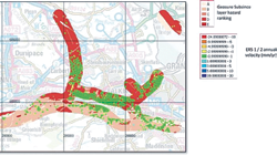
Motion data mapped onto Falkirk area in Scotland. A visualisation of the motion data obtained by radar satellite scans mapped onto the geological susceptibility map for the Falkirk area in Scotland. Ground motion is indicated by the small dots (displacement indicated in legend). The thick lines indicate the geological susceptibility for subsidence (A: low potential hazards; E: high potential hazard). Graphic courtesy of Live Land.
The services rely on a triple space alliance of satellite radar images, combined with satnav using satcoms to relay in-situ observations to a central system for analyzing ground motion around road and rail networks.
One promising approach is to use maps produced from radar satellites to identify potentially hazardous slopes, followed by repeat monitoring at ground level.
By taking regular observations, displacements across large areas can be measured with millimeter accuracy. Any sudden changes in motion indicate a potentially high-risk situation and invite closer scrutiny.
“There is no single way of solving the problem of monitoring natural hazards,” said ESA’s Rob Postema, “but these two projects demonstrate how combining techniques results in a powerful toolset for tackling a whole range of geological challenges.”
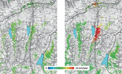
Satellite data reveals small geological movements Subsidence along the Val Nalps in Switzerland. Results on the left are obtained from ERS-1/2 data from 1992 to 2000; the results on the right are from Envisat data from 2004–10. Graphic courtesy of MATIST.
The Live Land study, led by CGI in the UK, looked at how to combine information from satellite radar scans, geology and weather forecasts to come up with risk maps that give enough warning to reduce the disruption and cost associated with landslide and subsidence on selected roads and railways in Scotland.
For example, an area of steep slopes and wet soil that is expecting heavy rainfall is at a higher risk of a landslide—therefore this would be highlighted in the maps.
Similarly, the Matist project, led by Gamma Remote Sensing and Consulting in Switzerland, combined satellite and terrestrial radar information and satnav to follow ground movements in the mountainous regions of Switzerland and Austria, notably covering the dense rail networks and Austria’s main road network.
These studies used existing Earth observation (EO) data, but Europe’s Sentinel satellites will become a valuable resource once they come online.
Rob Postema added, “In coming years, I expect to see a great many more innovative applications that make use of satellite data and capabilities, such as Earth observation and satellite navigation for keeping a watchful eye on phenomena of ground motion and the associated risks.”
Air Force Space Command—Budget Cuts = Growing Threat To Space Ops
Until recently, space was a peaceful domain where orbital and flying craft were unprotected, but adversaries now are developing systems designed to counter advantages gained by those using such space capabilities, the commander of Air Force Space Command—General William L. Shelton—said recently.

The Advanced Extremely High Frequency, or AEHF, system is a joint service satellite communications system that provides survivable, global, secure, protected and jam-resistant communications for high-priority military ground, sea and air assets. Advanced EHF allows the National Security Council and unified combatant commanders to control tactical and strategic forces at all levels of conflict through general nuclear war and supports the attainment of information superiority.
The Advanced Extremely High Frequency, or AEHF, system is a joint service satellite communications system that provides survivable, global, secure, protected and jam-resistant communications for high-priority military ground, sea and air assets. Advanced EHF allows the National Security Council and unified combatant commanders to control tactical and strategic forces at all levels of conflict through general nuclear war and supports the attainment of information superiority.
“Our satellites were not built with such threats in mind,” Shelton said. There hasn’t been a launch failure in 72 consecutive national security launches, he added, and satellites have lasted so much longer than their designed lifespan that the nation accidentally gained overlap between “father and daughter” satellites. “Space largely has been a peaceful sanctuary up to this point,” the general said, “and due to the cost of each of these intricate machines, we build just enough capability and build it just in time. We don’t really plan for anything but success.” Now, he said, “we have a clear and present danger to contend with that I believe must change our calculus on resiliency.”
Traffic is building in space, as many new entrants have joined the ranks of spacefaring nations and counter-space capabilities are becoming more concerning, Shelton explained. The Air Force must adapt its satellite constellations in response to such growing threats and elevate its game in space situational awareness, he said. And, the general said, Air Force Space Command is addressing this challenging space environment in the midst of a decreasing budget outlook.
“Space forces are foundational to every military operation, from humanitarian to major combat operations. It really doesn’t matter—space has to be there—continuously deployed in place, providing communications, missile warning, navigation, space surveillance and weather services,” Shelton said. Still, he added, Space Command’s share of reductions as part of overall Air Force reductions included a space surveillance asset that saved $6 million per year, an operationally useful sensor redundancy at launch bases that cut another few million dollars per year, and drastic cuts in headquarters contractor support that saved money but has substantially reduced capability.

“All told, we cut close to $1 billion from our annual budget in fiscal year 2013 and [fiscal] 2014 combined,” the general said. “The bottom line on our budget situation is this: We made the needed adjustments in fiscal years 2013 and 2014], and [fiscal] 2015 right now looks like it will be feasible,” he added. “But the law of the land is still sequestration for [fiscal] 2016 and beyond. Should Congress decide not to grant relief from [the severe budget cuts of] sequestration, I don’t know how my command can absorb the mandated reductions.”
To elevate the Air Force’s game in space situational awareness, Shelton explained his priorities for future satellite constellations as a nexus, aiming for an overlap of required capability, resilience and affordability. To illustrate the idea, he used the Air Force’s Advanced Extremely High Frequency, or AEHF, satellite constellation as
an example.
“This is the constellation the president would use in existential circumstances for the United States to command and control nuclear forces and to ensure continuity of the United States government,” Shelton said. The required constellation consists of four satellites, just enough for worldwide assured coverage, he added. If an adversary took out one satellite in the constellation, a geographic hole would open, potentially preventing the president from communicating with forces in that part of the world, the general said. “We’re looking at a range of options to make this scenario much less probable—for example, disaggregating our constellations for increased flexibility and survivability.”
The satellite carries strategic and tactical communications packages, Shelton said, explaining disaggregation. If the payloads were separated onto two or three satellites, he said, they would be much more resilient to a single shot, and each satellite would be less complex, would weigh less and would cost less to launch.
Air Force Space Command is also considering the following possibilities, Shelton said:
• Hosting payloads on commercial or other government satellites
• Lowering the cost or complexity of getting capability and capacity into space
• Leveraging commercial capability such as satellite communications rather than building dedicated military satellites
• Exploring partnerships with other nations to share the responsibility of sustaining critical space capabilities
“We’ve already done this with our Wideband Global SATCOM Satellite,” he added, “and partnered with Australia, the Netherlands, New Zealand, Canada, Denmark and Luxembourg.” Shelton said he believes the Air Force needs less complexity and more flexibility in its constellations, and that it will have to make decisions soon on its longer-term approaches.
“Our need date is the mid-2020s for replacements to the current satellite programs of record,” he said. “With long budgeting and development timelines, we’re looking at decisions in the [fiscal] 2017 program, which works through the Pentagon next year. We’re watching carefully as other nations significantly increase their investment in counter-space programs,” he continued. “We absolutely must adjust our approach and response, and the time for those decisions is approaching very rapidly.”
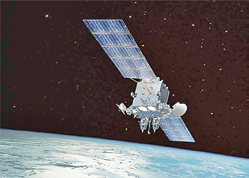
The Advanced Extremely High Frequency, or AEHF, system is a joint service satellite communications system that provides survivable, global, secure, protected and jam-resistant communications for high-priority military ground, sea and air assets. Advanced EHF allows the National Security Council and unified combatant commanders to control tactical and strategic forces at all levels of conflict through general nuclear war and supports the attainment of information superiority. This artistic rendition of AEHF is courtesy of the U.S. Air Force.
Another way the Air Force Space Command is improving its real-time space situational awareness, or SSA, is through a new architecture approved for SSA, Shelton said. The first critical step, he added, is the Joint Space Operations Center Mission System Program, or JMS. “This open-architecture, high-performance computing environment will be a several-orders-of-magnitude improvement over our current system,” he said. “And by the way, the last major upgrade to our current system was in 1994.” JMS will give Air Force Space Command a modern sensor data-processing capability plus a command-and-control environment for all space forces. The command also is making sensor improvements, Shelton said.
“We just awarded the contract for the Space Fence that will be built on Kwajalein Island in the Western Pacific,” he added. “This new radar will produce thousands of observations every day, covering almost all orbital inclinations.” The Space Fence will be much more sensitive and will be able to track unscheduled events in space, such as threatening satellite maneuvers and rocket body breakups that cause increased orbital debris traffic, Shelton said. “We’ve shipped a converted space-launch tracking radar to Western Australia to give us much better near-Earth space situational awareness in the Southern Hemisphere,” the general added, “and we will send to Australia a DARPA-developed telescope that is currently in New Mexico.”
DARPA is the Defense Advanced Research Projects Agency. The agency’s C-band mechanical tracking ground-based radar can accurately track up to 200 objects a day and can help identify satellites, their orbits and potential anomalies, according to a fact sheet about the system. When the radar is relocated to Australia, it will be the first Low Earth Orbit (LEO) space surveillance network sensor in the Southern Hemisphere. The new location will give needed southern and eastern hemispheric coverage that will lead to better positional accuracies and predictions. “This very capable telescope will do a great job of deep-space surveillance from that unique vantage point in Western Australia,” Shelton said.
Upcoming, the Air Force is scheduled to launch two operational satellites into near-geosynchronous orbit, he added. The satellites are part of the Geosynchronous Space Situational Awareness Program, or GSSAP. The GSSAP satellites will give U.S. Strategic Command space situational awareness data that allows for more accurate tracking and characterization of human-made orbiting objects, according to the Air Force News Service.
“This Neighborhood Watch twosome will help protect our precious assets in geosynchronous orbit,” Shelton said, “plus, they will be on the lookout for nefarious capabilities other nations might try to place in that critical orbital regime.” The general said the two satellites would provide a lot of knowledge about geo-traffic through the images they produce.
“GSSAP will also demonstrate enhanced maneuverability activities that include rendezvous and proximity operations during the developmental and operational test events shortly after launch,” he added.
The 1st Space Operations Squadron at Schriever Air Force Base in Colorado Springs will then have rendezvous and proximity operations in its toolkit to allow GSSAP to maneuver to get the best possible vantage point for collecting images when required, the general added. GSSAP represents a big leap forward in situational awareness at geosynchronous orbit, the general said. “With new data sources and a new system to process the data, later in this decade we will have truly enhanced our ability to monitor activity in space,” Shelton said. “And the big payoff [is that] we can transition from a reactive posture in space to becoming much more proactive, predicting space activity and anticipating outcomes.”
Story by Cheryl Pellerin, DoD News, Defense Media Activity