
A revolution is happening above our heads as companies race to take advantage of what is quickly becoming a precious resource — Earth’s orbit.
A few years ago, satellites were the size of garbage trucks and cost $400 million. Today, cubesats the size of a loaf of bread are an economical $1 million or less.

This thriving ecosystem has additionally lowered cost and technology barriers of entry with launch and on-orbit services bringing entrants to market faster than ever before experienced. Of the $250 billion in investment over the last decade, more than half has been secured since 2018.
Alongside this unprecedented growth, society continues to place its future and safety in the hands of the space community. Everyday, we rely on satellite technology.

Satellites help us find our way home, let us binge watch our favorite shows and protect us from domestic and foreign attack. Plus, the use cases for space continue to expand. The space economy is now home to mega-constellations that aim to provide global internet connectivity, ambitious space tourism programs and fleets of Earth Observation (EO) satellites that can help us understand and protect our world.
Earth’s orbit offers huge opportunities for innovation and profound advances that could shape the future of humanity. However, the situation is growing increasingly complex for satellite operators to protect these precious assets.
Not only are the number of satellites on-orbit planned to increase exponentially during the next decade, space is also cluttered with 10,000 metric tons of fast- moving debris. The chance of a collision has never been higher.
As satellite operators face more risk and less time to take action, they desperately need access to better data and a faster way to coordinate and share information to avoid collisions that put the entire space community in harm’s way.
An Exponential Rise in Conjunctions
Operating in Low Earth Orbit (LEO) is a high stakes endeavor. It is the most congested orbit with thousands of satellites and millions of pieces of debris flying at speeds of 17,000 miles per hour. At this speed, these objects are making their way around the globe every 90 minutes — additionally, new objects are added into the equation all the time.
Since 2018, there have been 11 major debris generating events. The most recent was a Russian ASAT test, which sent thousands of Kosmos 1408 fragments of debris into LEO, forcing the International Space Station crew to take evasive action.

There’s far more to come: Federal Communications Commission (FCC) and International Telegraph Union (ITU) filings suggest the number of satellites on-orbit will increase by a factor of 25 during the next decade.
SpaceX’s Starlink constellation will have 12,000 satellites on-orbit by the time that company has completed launching their constellation members.
Other companies appear even more ambitious, with some shooting to launch mega-constellations with satellites that number in the tens of thousands. All of this activity is driving an exponential rise in the number of potential collisions between objects on-orbit.
Today, the U.S. Government (USG) serves a vital role in monitoring the space environment and determining whether two objects have a likelihood of conjuncting. The 18th Space Control Squadron (18 SPCS), located on the central coast of California at Vandenberg Air Force Base, leverages a global network of radar telescopes to track space objects on a daily basis and provide the domestic and international operator community information about the risks posed to their assets.
The 18 SPCS scans the skies multiple times a day. They take these radar observations and then forecast which objects are likely to have a conjunction that may warrant a maneuver over the next few days. Once a potential conjunction passes a certain probability threshold, they generate warnings called Conjunction Data Messages (CDMs) that are sent to operators who sign up for these free alerts.
The 18 SPCS currently generates more than 500,000 of these warnings every single day. For the 800 or so satellite operators with equipment on-orbit, it’s no exaggeration to say the status quo is unsustainable.
With every satellite launch, Earth’s orbit becomes more dynamic and precarious. In 2019, a defunct Soviet satellite and an eight-ton Soviet rocket body avoided colliding by just 95 yards.
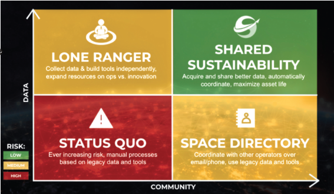
Here is one way to think about the situation and how to reduce the risk. On the x-axis we move across the community spectrum, from a single, siloed player to one that is more interconnected with the broader community. On the y-axis, we move from poor and incomplete data, to more accurate, more timely and more complete data. The ideal, and lowest risk quadrant is in the upper right, what we call Shared Sustainability. Here, rich and accurate data is combined from multiple sources. Sophisticated solutions help operators filter the signal from the noise and everyone in this bucket is part of Slingshot’s connected community, allowing for simple and timely coordination.
The resulting debris would have doubled the amount of tracked debris in LEO; meaning this single event would have been on par with 60 years’ worth of space-debris growth. For the space-based economy to safely continue on this path, operators have to find a better way to assess risk and coordinate with each other.
Collision Avoidance In The Age of Mega Constellations
Much of this assessment and coordination is currently conducted in a manner that undermines the ingenuity of the industry and its operators. Depending on the number of assets under your control, thousands of CDMs can arrive each day via email or through an in-house API. Judgments then have to be made on which are enough of a high risk to warrant expensive and disruptive maneuvers to avoid damage.
These decisions are often based on limited, low-fidelity data. The result can be an uninformed course of action with potentially ruinous consequences. A case in point is the February 2009 collision between an active Iridium satellite and a defunct Russian military satellite — despite calculations predicting the two would miss each other by almost 2,000 feet.
For CDMs involving two stakeholders, the lines of communication are also antiquated. A high-risk conjunction report can lead to a chain of emails while operators resolve the issue and decide who will do what, and when — and that’s assuming the operator is able to get in touch with the relevant counterpart. With more infrastructure being sent into orbit, limited space awareness across the board represents a significant risk to every operator.

There are too many manual processes, barriers to effective communication between stakeholders,and vital operational decisions being made with low fidelity data.
Fortunately, there’s a better way. It starts with higher quality data, improved CDM processing and seamless communication between stakeholders. These are the foundations operators need to increase certainty around conjunction outcomes and reduce the number of maneuvers required.
Slingshot Beacon: Shared Space Sustainability In Action
Slingshot Beacon is the industry’s first, two-sided, communication and collaboration platform. (See the chart.) Slingshot ingests and filters the daily avalanche of CDMs and facilitate direct collaboration between space stakeholders. Conjunctions that meet predefined criteria are highlighted, while mission plans, timelines and constraints are shared with all the relevant parties.
The result is a platform that de-risks conjunctions, fosters a more sustainable approach to operations, and saves satellite owners valuable time.

As commercial, scientific, and military capabilities in orbit scale up, it’s useful to think of space awareness across two spectrums: data depth and data sharing.
Incomplete or low fidelity data is one of the single biggest challenges operators must contend with on a regular basis. Slingshot Beacon enhances the CDM analysis process through the addition of the company’s advanced Machine Learning (ML) technology, third-party data sources, intuitive visualizations, and automated filtering.
Even when the data can be trusted, the current level of information sharing between satellite operators is far from ideal. Information silos and standalone processing methods are remnants of the industry’s early years. Both reduce interconnection within the space community and add friction where there should, instead, be a shared approach.
Slingshot Beacon includes several collaborative features that push the industry toward a status quo of Shared Sustainability. These include the option of one-to-one contact, community broadcast channels and a step-by-step CDM resolution process built on the transparent exchange of data.
It Pays To Work Smarter

The bottom line for operators is that every maneuver comes at a cost. The lifespan of a satellite depends on the efficient use of fuel, while service disruption caused by evasive action can be, well, disruptive.
With rich and accurate data from multiple sources, Slingshot Beacon allows operators to filter the signal from the noise, easily coordinate with each other and only maneuver when such becomes an absolute necessity.
Slingshot Beacon was developed to mitigate risks on-orbit and to enable safer satellite operations for all.

Learn more about Slingshot Beacon at this direct link...
Author Melanie Stricklan is the Co-Founder and Chief Executive Officer of Slingshot Aerospace.