
Spire Global Inc. is a satellite-powered data company that uses a large, distributed constellation of satellites to persistently collect radio frequency (RF) data at a global scale in near-real time. Founded in 2012, the company leverages proprietary Software Defined Radio (SDR) technology to collect radio frequency signals and extract information and intelligence from the RF spectrum.

The company specifically uses the smallsat form factor for data collection to take advantage of this spacecraft’s potential for exponential technology trajectory. Advances in miniaturization reaching the market from the consumer electronics and robotics industries on Earth enable smallsats to perform more sophisticated missions at ever smaller Size, Weight, and Power (SWaP) requirements.

Data is downloaded from each spacecraft through Spire’s own global ground station network. Spire uses this ‘raw data’ to produce high-value information products on the movement of world resources as well as on global weather and climate conditions.
This article outlines the background, current status and existing customers of Spire’s capabilities to monitor, detect and geolocate RF signals. This service will be available across a number of frequency bands as both stand-alone and augmentative products.
This service is expected to have an immediate effect on entities that use the Automatic Identification System (AIS), Automatic Dependent Surveillance- Broadcast (ADS-B) and Global Navigation Satellite System (GNSS)-based products, all the while greatly expanding into custom RF monitoring capabilities in the VHF, UHF, L-, S-, X-, Ku- and Ka-bands (among others).
Spire controls all stages of the RF spectrum monitoring enterprise, from satellite design and manufacturing to ground station management and payload tasking. This means that Spire is uniquely positioned to provide a uniform and seamless RF spectrum monitoring service.
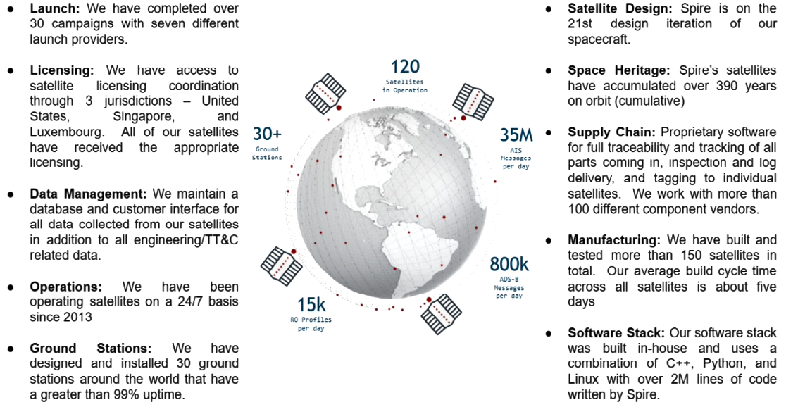
With more than 150 satellites launched, Spire is able to provide persistent, near-global coverage of a wide range of RF observables and payload telemetry. Additionally, Spire operates a global network of 30+ ground stations, that allows for timely data product downlinks for processing and distribution to clients. From the firm’s place as a world leader in satellite, commercial, data services and analysis, Spire is expanding into the RF spectrum monitoring domain.
For nearly a decade, Spire has harvested RF signals for a variety of applications. Spire’s push for robust and resilient RF spectrum monitoring capabilities will provide even more insights for customers, such as:
• AIS position validation
• Near real-time GNSS jamming detection and geolocation
• Custom RF spectrum monitoring
All of these capabilities are under contract today, in addition to Spire’s intent to continually expand into other frequency bands of interest. Pairing these upcoming capabilities with existing ones positions Spire as a unique and powerful commercial data partner that is able to provide persistent, immediate and actionable insights on global situations from a variety of varying measurements.
Technical Background
Mission Profile
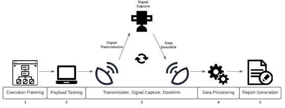
The basic RF monitoring mission consists of the following five steps:
1. Execution Planning can be done on the ground or automated onboard the satellites. It is driven by customer requirements of collection time, geographic area, signal type, and desired analytics
2. Payload Tasking schedules and tasks relevant payloads with the mission executables.
3. Transmission of the signal of interest is generally not Spire-controlled, and comes from cooperative or non- cooperative 3rd party emitters. Occasionally, Spire may transmit a calibration signal in the area for enhanced RF monitoring capabilities. Signal capture implies Spire has successfully collected the signals of interest (SOI). Downlink of the captured information is scheduled using as many of the Spire ground stations as needed to fulfill the client’s latency requirements.
4. Data Processing takes the captured, downlinked information and parses it for relevant signal attributes such as geolocation, modulation scheme, and power. This processing can be done onboard the satellite or on the ground.
5. Report Generation produces and formats the information obtained from the missions to the client.

Infrastructure
Infrastructure RF spectrum monitoring requires an extensive network of satellites, ground stations, and operational infrastructure to successfully execute missions with useful real-world product performance. Time-sensitive, temporally persistent, and geographically-specific client mission requests require a proliferated set of global satellite assets, a high number of ground stations, and intersatellite links to enable near-real time, actionable dissemination of spectrum insights.
• Spire Ground Stations
Spire operates a global network of 30 ground stations and is continually expanding this network to improve data downlink capacity and data latency. The ground stations support UHF and S-band transmit and receive functions. Spire is rolling out X-band downlink capability to support large-file missions (e.g., IF collections), targeting completion in 2022. Currently Spire has more than 70+ antenna systems, >70,000 contacts and >300,000 contact minutes per month. Spire also has partnerships with third party ground station providers to provide surge capacity on-demand.
• Spire Satellites
Spire’s 120+ satellite network cumulatively carries hundreds of payloads. Collection payloads must be capable of capturing or extracting phase information from a particular signal of interest. This phase captures many types of phenomena that Spire uses to infer attributes about the transmitted signal, including the modulation type, the induced Doppler, the environmental mediums affecting the signal, and even minutia on the RF transmitter itself. From these inflections in phase, Spire looks to detect, characterize, and geolocate the transmitted signals. Once the appropriate data has been captured, RF monitoring requires precise position, navigation, and timing (PNT) knowledge across multiple RF-collecting platforms. Therefore, a satellite capable of RF monitoring must have these attributes and can be differentiated based on the spectrum it is able to monitor.
• Signal Processing
There exist many forms and methods for detecting, extracting, and geolocating signals of interest. RF monitoring requires precise PNT knowledge across multiple platforms, circumstantial transceiver geometry, and a solution choice from a suite of algorithms that vary in effectiveness depending on the collection scenario. By collecting the phase for the signal(s) of interest, which captures many type of signal phenomena, Spire can infer attributes on the transmitted signal including the modulation type, the induced Doppler, the environmental mediums affecting the signal, and even minutia on the RF transmitter itself.
Consider a stationary ship transmitting an AIS signal. The signal impinges upon a Spire satellite. The fast speeds of the LEO satellite induce a Doppler effect that is captured as a time-varying, phase shift in the received signal. This phase shift can, in some circumstances, be modeled and unambiguously mapped to an emitter location, even if the Spire satellite has no prior knowledge of the ship’s location (i.e. if the ship is reporting an erroneous GPS coordinate). If multiple satellites capture the signal simultaneously, or perhaps in succession, unique proprietary algorithms are available to detect and geolocate the signal.
This same process is used for ADS-B, GNSS, and any other signal of interest which Spire satellite payloads are able to capture, though the algorithms used to detect the signal vary widely with the signal type. Signal geolocation can also use nonlinear filtering, time frequency difference of arrival (TFDOA), and parameterized covariance matrix algorithms when multiple satellites are present to simultaneously collect.
Example Applications
Spire is engaged in several sponsored activities to extend the capability of our standard LEMUR VHF, UHF, and L-band capable platforms to collect and geolocate signals in a wider range of the RF spectrum. In order to enable these emitter detection and geolocation capabilities, Spire has developed custom RF front ends, RF intersatellite links (S-band), and a precision GNSS receiver to deliver coherent timing and frequency reference to every collection payload. These building blocks coupled with purpose-built RF front ends and apertures will enable Spire to collect, process, and geolocate signals of interest across various signal types.
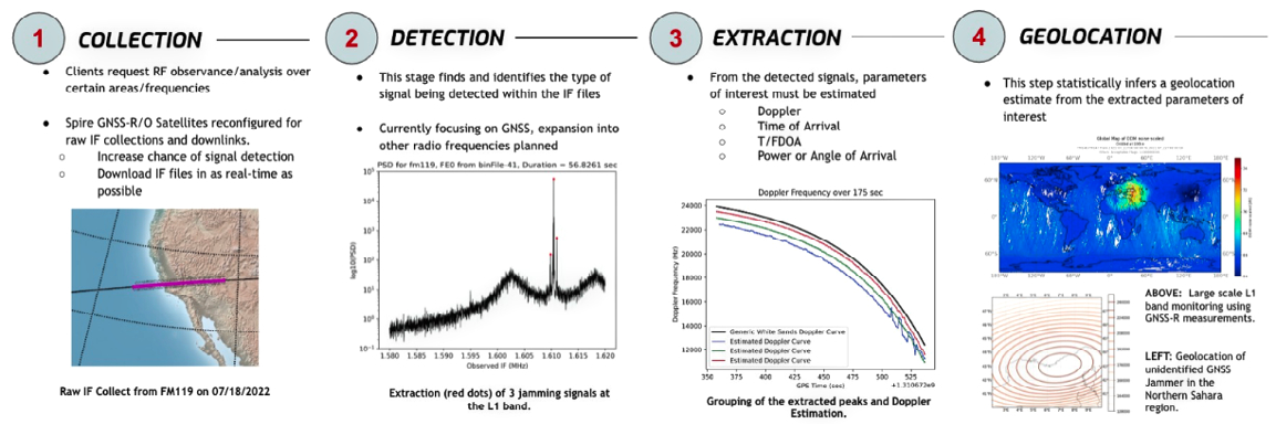
• GNSS Jamming Detection and Geolocation
In recent years, effective jamming of GNSS users, purposely and not, have increased across the world. These jammers, generically referred to as GNSS radio frequency interference (RFI) sources, degrade the quality, reliability, and usability of GNSS/GPS position, navigation, and time (PNT) services. Knowledge of the power, location, and directionality of these jamming events can significantly help local entities maintain safe and consistent activities.
The figure below left is a GNSS jamming collection Spire completed over the Saharan Desert. The Spire satellite collected raw, intermediate frequency (IF) data in the highlighted area on the image to the far left. A snapshot of a power spectral density (PSD) plot is shown centrally, where 5 peaks can be seen. These 5 peaks, when tracked and extracted over time, produce the Doppler curves shown on the right. Two of the curves were able to be geolocated to potential jamming locations with approximate error ellipsoids of just under 10 kilometers in the ECEF coordinate system.
• Custom RF Collections
Spurious RF emissions, intentional or not, can affect local infrastructure in a harmful manner. Procuring a set of sensors to detect, quantify, and geolocate the RF emissions from space can quickly bring about the right plan of action by first disseminating the nature of the interference or unknown signal. The customizable SDRs onboard Spire satellites allows for custom collection campaigns to be executed expediently. For instance, the proliferation of commercial SATCOM services have enabled Terrorists, Narcotics traffickers and smugglers to employ L-Band SATCOM phones to conduct their operations. Additionally, local governments or commercial entities could query Spire satellites to persistently monitor the interested spectral bands over certain geographical areas, geolocating the emissions if any are detected with applications to spectrum usage validation or using traffic pattern monitoring for satcom.
Consider a stationary ship transmitting an AIS signal. The signal impinges upon a Spire satellite. The fast speeds of the LEO satellite induce a Doppler effect that is captured as a time-varying, phase shift in the received signal. This phase shift can, in some circumstances, be modeled and unambiguously mapped to an emitter location, even if the Spire satellite has no prior knowledge of the ship’s location (i.e. if the ship is reporting an erroneous GPS coordinate). If multiple satellites capture the signal simultaneously, or perhaps in succession, unique proprietary algorithms are available to detect and geolocate the signal.
This same process is used for ADS-B, GNSS, and any other signal of interest which Spire satellite payloads are able to capture, though the algorithms used to detect the signal vary widely with the signal type. Signal geolocation can also use nonlinear filtering, time frequency difference of arrival (TFDOA), and parameterized covariance matrix algorithms when multiple satellites are present to simultaneously collect.
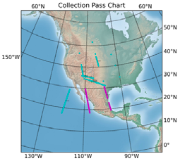
Following reports of jamming activity in the Southwest United States, within a few days Spire tasked 7 satellites whose collecting positions are highlighted. From our collections, two to five GPS jamming signals were detected with geolocation fixes produced.
Path Forward
1. Select Current Programs
Space Systems Command (SSC) DEEP Program
In the DEEP Program, Spire will provide GPS telemetry data to Slingshot Aerospace. The focus of the program is to build a prototype RF Spectrum Awareness capability to detect and localize GNSS RFI using strictly commercial LEO constellation observables.
SNC L-Band Emitter Detection & Geolocation Technology Program
Spire’s cluster of four 6U satellites built for Sierra Nevada Corporation (SNC) will enhance SNC technology that detects and geolocates certain objects based on targeted RF emissions. The program will provide valuable insight into how military and government organizations can safeguard against RF and GPS interference.
Australian Office of National Intelligence (ONI) NICSAT Program
Spire designed, built, and launched a 6U satellite platform for ONI with the capability of on-board computing and processing of machine learning and artificial intelligence across multi- modal data.
UK DASA Next-Gen Space Tech Funding for RF Signals Detection and Geolocation
This program will support the demonstration of radio frequency (RF) signals detection and geolocation from 3U satellites built and operated by Spire. Spire will demonstrate its ability to geolocate RF signals emitted near the Earth’s surface, focusing on L-Band SATCOM signals, and investigate further geolocation techniques using Spire satellites.
ESA NAVISP Project
Spire is demonstrating a prototype service for space-based surveillance, detection, and geolocation of GNSS interference.
Expectations

This article outlines the motivation, background, and current status of Spire’s capabilities to monitor, detect, and geolocate radio frequency (RF) signals. Spire is looking to leverage our existing constellation and planned additions to provide persistent, global, near real-time delivery of RF insights in the future. This enterprise into the RF spectrum monitoring realm looks to further position Spire as the world leader in smallsat-based commercial data and data analysis.
ir.spire.com
Jeroen Cappaert is one of Spire Global’s co-founders and serves as the Chief Technology Officer at Spire, focusing on ensuring future technology developments deliver what the business needs. With a background in electronics engineering and aerospace engineering, Jeroen’s previous work and research includes high-enthalpy flow simulation, computational mechanics and fluid dynamics, spacecraft avionics and payload design, geo-engineering, and low-thrust astrodynamics at NASA Ames, Von Karman Institute for Fluid Dynamics, International Space University. Jeroen’s education includes a MSc in Space Studies from the International Space University.